Loye-sur-Arnon
| Loye-sur-Arnon | |
|---|---|
| Commune | |
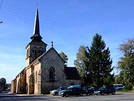 The church of Saint-Martin, in Loye-sur-Arnon | |
 Loye-sur-Arnon Location within Centre-Val de Loire region  Loye-sur-Arnon | |
| Coordinates: 46°39′13″N 2°23′14″E / 46.6536°N 2.3872°ECoordinates: 46°39′13″N 2°23′14″E / 46.6536°N 2.3872°E | |
| Country | France |
| Region | Centre-Val de Loire |
| Department | Cher |
| Arrondissement | Saint-Amand-Montrond |
| Canton | Châteaumeillant |
| Government | |
| • Mayor (2008–2014) | Jean-Paul Joliet |
| Area1 | 34.15 km2 (13.19 sq mi) |
| Population (2008)2 | 309 |
| • Density | 9.0/km2 (23/sq mi) |
| Time zone | UTC+1 (CET) |
| • Summer (DST) | UTC+2 (CEST) |
| INSEE/Postal code | 18130 /18170 |
| Elevation |
189–248 m (620–814 ft) (avg. 224 m or 735 ft) |
|
1 French Land Register data, which excludes lakes, ponds, glaciers > 1 km2 (0.386 sq mi or 247 acres) and river estuaries. 2 Population without double counting: residents of multiple communes (e.g., students and military personnel) only counted once. | |
Loye-sur-Arnon is a commune in the Cher department in the Centre-Val de Loire region of France.
Geography
An area of lakes, forestry and farming comprising a village and several hamlets situated by the banks of the river Arnon, some 32 miles (51 km) south of Bourges, west of Canton (11 km Saulzais Le Potier and 12 km from Saint-Amand-Montrond), on both the D997 and the D951 roads, covering an area of 3414 ha, 600 ha of forest and 80 km of road and bordered on 9 km from the river.
Its economic activity consists of ten farms ranging from 6-250 hectares and employing them in every 5 employees, 9 craftsmen and traders are also part of the local economy.
Several organizations are involved in the animation of the village: a festival committee, a brotherhood of St. Vincent, an association of parents "Grande Récrée" former tobacco growers, a fishing company and a friendly hunters .
The kindergarten, renovated in 2003, is part of the teaching grouping Arcomps - Ardenais - Loye sur Arnon, and the canteen (which hosts an average of 50 children per room) are located on the town. The canteen is run by an association of parents.
The village lies on the circuit of the pilgrims of Saint Jacques de Compostela, whose house to host the Old Forest, and is crossed by numerous hiking trails, one will discover the Roman Bridge (fully restored in 2002 under the aegis of Historical Monuments).
Since 2003, a multipurpose room with parking is part of municipal assets and its Church of St. Martin of the twelfth century.
Artistic Gardens Drulon bring a dynamic tourism for all gardening enthusiasts. Also recall that the town has for years 1 flower at the departmental contest of the cities and villages in bloom standout category.
Population
| Historical population | ||
|---|---|---|
| Year | Pop. | ±% |
| 1962 | 471 | — |
| 1968 | 488 | +3.6% |
| 1975 | 390 | −20.1% |
| 1982 | 329 | −15.6% |
| 1990 | 303 | −7.9% |
| 1999 | 308 | +1.7% |
| 2008 | 309 | +0.3% |
Sights
- The church of St. Martin, dating from the twelfth century.
- The ruins of a feudal castle at Buchet.
- The fifteenth-century chateau at Drulon.
- The seventeenth-century manorhouse des Girouettes.
- Three watermills, at Drulon, Graveaux and Méséreau.
See also
References
- Communauté de Communes Terres du Grand Meaulnes
- INSEE
External links
| Wikimedia Commons has media related to Loye-sur-Arnon. |