Saint-Florent-sur-Cher
| Saint-Florent-sur-Cher | ||
|---|---|---|
| Commune | ||
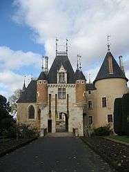 Town hall | ||
| ||
 Saint-Florent-sur-Cher Location within Centre-Val de Loire region  Saint-Florent-sur-Cher | ||
| Coordinates: 46°59′47″N 2°15′09″E / 46.9964°N 2.2525°ECoordinates: 46°59′47″N 2°15′09″E / 46.9964°N 2.2525°E | ||
| Country | France | |
| Region | Centre-Val de Loire | |
| Department | Cher | |
| Arrondissement | Bourges | |
| Canton | Chârost | |
| Intercommunality | CC Fercher – Pays florentais | |
| Government | ||
| • Mayor (2008–2014 - 2014–2020) | Roger Jacquet | |
| Area1 | 22.41 km2 (8.65 sq mi) | |
| Population (2008)2 | 6,692 | |
| • Density | 300/km2 (770/sq mi) | |
| Time zone | UTC+1 (CET) | |
| • Summer (DST) | UTC+2 (CEST) | |
| INSEE/Postal code | 18207 /18400 | |
| Elevation |
117–164 m (384–538 ft) (avg. 157 m or 515 ft) | |
|
1 French Land Register data, which excludes lakes, ponds, glaciers > 1 km2 (0.386 sq mi or 247 acres) and river estuaries. 2 Population without double counting: residents of multiple communes (e.g., students and military personnel) only counted once. | ||
.svg.png)
Saint-Florent-sur-Cher is a commune in the Cher department in central France.
Population
| Historical population | ||
|---|---|---|
| Year | Pop. | ±% |
| 1962 | 5,453 | — |
| 1968 | 6,408 | +17.5% |
| 1975 | 6,535 | +2.0% |
| 1982 | 7,611 | +16.5% |
| 1990 | 7,358 | −3.3% |
| 1999 | 6,900 | −6.2% |
| 2008 | 6,692 | −3.0% |
See also
References
| Wikimedia Commons has media related to Saint-Florent-sur-Cher. |
| Authority control |
|---|
This article is issued from
Wikipedia.
The text is licensed under Creative Commons - Attribution - Sharealike.
Additional terms may apply for the media files.