Phongsali
| Phongsali ຜົ້ງສາລີ | |
|---|---|
| City | |
 | |
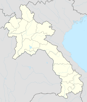 Phongsali Location in Laos | |
| Coordinates: 21°41′N 102°06′E / 21.683°N 102.100°E | |
| Country |
|
| Admin. division | Phongsali Province |
| Population | |
| • Religions | Buddhism |
| Time zone | UTC+7 (ICT) |
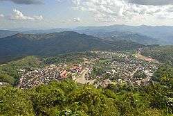
Phongsali or Phongsaly (Lao: ຜົ້ງສາລີ) is the capital of Phongsali Province, Laos. It is the northernmost among provincial capitals in Laos opposite Attapeu in the south. The town has about 6,000 inhabitants and is located at approximately 1,430 meters on the slopes of Mount Phu Fa (1,625 meters). Phongsali has pleasant summer temperatures around 25-30 °C, but it has frequent rain. In winter from November to March it is, however, fairly cool, with daytime temperatures between 10-18 °C, but still mostly sunny.
In the centre of the town are houses built in Yunnanese style with ornate wooden fronts. This is quite rare as the preserved city was not destroyed like other cities in northern Laos during the Vietnam War by bombing.
A 400-year-old tea plantation is about 18 kilometers away in the village of Ban Komaen, which according to some tea experts has some of the oldest tea trees in the world. The large root system of the old trees extends deep into the mineral-rich soil and gives the "Phongsali tea" a distinct aroma and taste.
Languages
Climate
Phongsali has a subtropical highland climate (Köppen climate classification: Cwb).
| Climate data for Phongsali | |||||||||||||
|---|---|---|---|---|---|---|---|---|---|---|---|---|---|
| Month | Jan | Feb | Mar | Apr | May | Jun | Jul | Aug | Sep | Oct | Nov | Dec | Year |
| Average high °C (°F) | 19.2 (66.6) |
21.4 (70.5) |
24.5 (76.1) |
26.0 (78.8) |
26.3 (79.3) |
25.1 (77.2) |
24.8 (76.6) |
25.0 (77) |
25.0 (77) |
23.3 (73.9) |
21.2 (70.2) |
19.3 (66.7) |
23.4 (74.2) |
| Daily mean °C (°F) | 12.5 (54.5) |
13.9 (57) |
16.7 (62.1) |
19.1 (66.4) |
21.0 (69.8) |
21.2 (70.2) |
21.2 (70.2) |
21.1 (70) |
20.6 (69.1) |
18.5 (65.3) |
15.9 (60.6) |
13.1 (55.6) |
17.9 (64.2) |
| Average low °C (°F) | 5.9 (42.6) |
6.5 (43.7) |
8.9 (48) |
12.3 (54.1) |
15.7 (60.3) |
17.4 (63.3) |
17.7 (63.9) |
17.3 (63.1) |
16.2 (61.2) |
13.8 (56.8) |
10.7 (51.3) |
7.0 (44.6) |
12.4 (54.4) |
| Average precipitation mm (inches) | 15 (0.59) |
32 (1.26) |
33 (1.3) |
89 (3.5) |
189 (7.44) |
265 (10.43) |
363 (14.29) |
356 (14.02) |
173 (6.81) |
99 (3.9) |
49 (1.93) |
28 (1.1) |
1,691 (66.57) |
| Source: [1] | |||||||||||||
References
- ↑ "Climate: Phongsali". Climate-Data.org. Retrieved December 22, 2017.
Further reading
- Kingsadā, Thō̜ngphet, and Tadahiko Shintani. 1999 Basic Vocabularies of the Languages Spoken in Phongxaly, Lao P.D.R. Tokyo: Institute for the Study of Languages and Cultures of Asia and Africa (ILCAA).
- Shintani, Tadahiko, Ryuichi Kosaka, and Takashi Kato. 2001. Linguistic Survey of Phongxaly, Lao P.D.R. Tokyo: Institute for the Study of Languages and Cultures of Asia and Africa (ILCAA).
- Kato, Takashi. 2008. Linguistic Survey of Tibeto-Burman languages in Lao P.D.R. Tokyo: Institute for the Study of Languages and Cultures of Asia and Africa (ILCAA).
Coordinates: 21°41′N 102°06′E / 21.683°N 102.100°E
| Attapeu | |
|---|---|
| Bokeo | |
| Bolikhamsai | |
| Champasak | |
| Houaphanh | |
| Khammouane | |
| Luang Namtha | |
| Luang Prabang | |
| Oudomxay | |
| Phongsaly | |
| Salavan | |
| Savannakhet | |
| Sekong | |
| Vientiane |
|
| Vientiane (Viengchan) |
|
| Xaignabouli |
|
| Xaisomboun |
|
| Xiangkhouang | |