Sapulpa, Oklahoma
| Sapulpa, Oklahoma | |
|---|---|
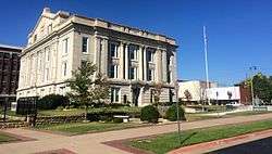 Creek County Courthouse, 2014 | |
| Motto(s): "Oklahoma's Most Connected City" | |
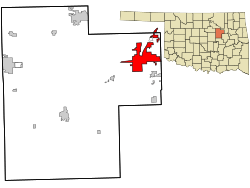 Location within Creek County and Oklahoma | |
 Location in the United States | |
| Coordinates: 36°0′13″N 96°6′17″W / 36.00361°N 96.10472°WCoordinates: 36°0′13″N 96°6′17″W / 36.00361°N 96.10472°W | |
| Country | United States |
| State | Oklahoma |
| Counties | Creek, Tulsa[1] |
| Area | |
| • Total | 25.1 sq mi (65.1 km2) |
| • Land | 24.3 sq mi (63.0 km2) |
| • Water | 0.8 sq mi (2.1 km2) |
| Elevation | 715 ft (218 m) |
| Population (2013 est.) | |
| • Total | 20,836 |
| • Density | 856/sq mi (330.6/km2) |
| Demonym(s) | Sapulpan |
| Time zone | UTC-6 (Central (CST)) |
| • Summer (DST) | UTC-5 (CDT) |
| ZIP codes | 74066-74067 |
| Area code(s) | 539/918 |
| FIPS code | 40-65400[2] |
| GNIS feature ID | 1097835[3] |
| Website |
www |
Sapulpa is a city in Creek and Tulsa counties in the U.S. state of Oklahoma. The population was 20,544 at the 2010 United States census, compared to 19,166 at the 2000 census.[4] As of 2013 the estimated population was 20,836.[5] It is the county seat of Creek County.[6]
History
Early history
The town was named after the area's first permanent settler, a full-blood Lower Creek Indian named Sapulpa, of the Kasihta Tribe, from Osocheetown, Alabama.[7] About 1850, he established a trading post near the meeting of Polecat and Rock creeks (about one mile (1.6 km) southeast of present-day downtown Sapulpa). When the Atlantic and Pacific Railroad (later known as the Frisco) built a spur to this area in 1886, it was known as Sapulpa Station. The Sapulpa post office was chartered July 1, 1889. The town was incorporated March 31, 1898.[8][9]
Controversy over Creek County Seat location
After Oklahoma became a state, each county held an election to determine the location of the county seat. Sapulpa competed with Bristow for county seat of Creek County. After five years of contested elections and court suits, the question was settled by the Oklahoma Supreme Court on August 1, 1913. Sapulpa was ruled the winner. The county courthouse was completed in 1914, replacing an earlier structure built in 1902.[7]
Economic development
The area around Sapulpa mainly produced walnuts when the town was founded. In 1898, the Sapulpa Pressed Brick was established, followed in a few years by the Sapulpa Brick Company. This began the clay products industry. The Frisco built a railyard in Sapulpa and by 1900 designated Sapulpa as the location of an overhaul base for its rolling stock.[7] The founding of Premium Glass Company in 1912 marked Sapulpa's entry to glass manufacturing. Premium Glass was absorbed into Liberty Glass Company in 1918. Other glass producers in the city were Bartlett-Collins Glass Company, Schram Glass Company, and Sunflower Glass Company. According to the Encyclopedia of Oklahoma History, Sapulpa became known as "The Crystal City of the Southwest".[10] Sapulpa is also the home of Frankoma Pottery.
Geography
Sapulpa is located in the northeast corner of Creek County at 36°0′13″N 96°6′17″W / 36.00361°N 96.10472°W (36.003536, -96.104822).[11] A small portion of the city extends north into Tulsa County and was annexed into the city in 2004. Downtown Tulsa is 14 miles (23 km) to the northeast via Interstate 44. The Creek Turnpike (State Highway 364) branches east from I-44 in northeastern Sapulpa and provides a southern and eastern bypass of Tulsa.
In January 2018, the Sapulpa City Council voted to approve the annexation of approximately 300 acres of land in West Tulsa. The land is bordered to the north by 51st street, to the south by Southwest Blvd, and to the west by 65th West Avenue. Originally, this annexation included the future site of the interchange of the Gilcrease Expressway and I-44. However, the city has now planned to de-anex this area back to the city of Tulsa.
According to the United States Census Bureau, the city of Sapulpa has a total area of 25.1 square miles (65.1 km2), of which 24.3 square miles (63.0 km2) is land and 0.81 square miles (2.1 km2), or 3.21%, is water.[12]
Demographics
| Historical population | |||
|---|---|---|---|
| Census | Pop. | %± | |
| 1900 | 891 | — | |
| 1910 | 8,283 | 829.6% | |
| 1920 | 11,634 | 40.5% | |
| 1930 | 10,533 | −9.5% | |
| 1940 | 12,249 | 16.3% | |
| 1950 | 13,031 | 6.4% | |
| 1960 | 14,282 | 9.6% | |
| 1970 | 15,159 | 6.1% | |
| 1980 | 15,853 | 4.6% | |
| 1990 | 18,074 | 14.0% | |
| 2000 | 19,166 | 6.0% | |
| 2010 | 20,544 | 7.2% | |
| Est. 2015 | 20,579 | [13] | 0.2% |
| Sources:[2][5][14][15] | |||
As of the 2010 census, there were 20,544 people, 8,015 households, and 5,497 families residing in the city. The population density was 844.3 people per square mile. There were 8,903 housing units at an average density of 435.4 per square mile (168.2/km²). The racial makeup of the city was 77.5% White, 3.0% African American, 10.9% Native American, 0.6% Asian, 0.2% Pacific Islander, 1.5% from other races, and 6.3% from two or more races. Hispanic or Latino of any race were 4.1% of the population.[16]
There were 7,430 households out of which 32.5% had children under the age of 18 living with them, 54.8% were married couples living together, 12.9% had a female householder with no husband present, and 27.9% were non-families. 24.2% of all households were made up of individuals and 10.5% had someone living alone who was 65 years of age or older. The average household size was 2.54 and the average family size was 3.00.
In the city, the population was spread out with 26.1% under the age of 18, 7.9% from 18 to 24, 27.5% from 25 to 44, 23.7% from 45 to 64, and 14.8% who were 65 years of age or older. The median age was 37 years. For every 100 females, there were 91.2 males. For every 100 females age 18 and over, there were 86.9 males.
The median income for a household in the city was $40,372 and the median income for a family was $52,639. Males had a median income of $30,524 versus $21,609 for females. The per capita income for the city was $22,275. About 11.5% of families and 16.3% of the population were below the poverty line, including 15.2% of those under age 18 and 17.4% of those age 65 or over.[17]
Culture and education

In 2013, the Sapulpa Creek Community Center graduated a class of 14 from its Muscogee Creek language class.[18]
Newspaper controversy
The Sapulpa Daily Herald gained national media attention in early November 2008 for not reporting the election of Barack Obama as president, reporting only that John McCain had won among the voters of Creek County. Critics charged that the omission related to racism, as Obama's victory as the first African American elected president was an historic event. The newspaper maintains that it only covers local news events. The newspaper had covered every single presidential victory prior to the Obama victory.[19]
Notable people
- Bob Ballinger, Republican member of the Arkansas House of Representatives, taught history in Sapulpa from 1999 to 2002.[20]
- The Collins Kids, musicians, Lorrie and Larry Collins, resided near Sapulpa in the early 1950s.[21]
- Joe Haymes, jazz orchestra leader, lived here for extended periods in the 1940s and '50s.[22]
- Regina Holliday, art teacher, artist, muralist, and patient rights advocate, graduated from Sapulpa High School.[23]
- George William Miller (b. March 9, 1925 – d. March 17, 2006) was born in Sapulpa. He served as the 65th U.S. Secretary of the Treasury under President Carter from August 6, 1979, to January 20, 1981. He previously served as the 11th Chairman of the Federal Reserve, where he began service on March 8, 1978.
- Don Wallace, former Major League Baseball player (who played for the Los Angeles Angels in the 1960s), was born in Sapulpa.[24]
- Shara Worden, lead singer and songwriter for My Brightest Diamond, grew up in Sapulpa.[25] She was previously a backup vocalist for Sufjan Stevens and the frontwoman of Awry.
- Prizefighter, musicians, Popular [pop-punk] Christian music band founded in Sapulpa in 1997 and performed with notable Christian music acts MercyMe, Skillet, Superchick, Delirious. They wrote the hit song "I Kissed Dating Goodbye" which hit #3 on the True Life Radio Top 100 in 2004 and 2005. Founding Members included Josh Porter, Jon LaFevers, Billy Young, and Adam "Tico" Hernandez [26] who now plays with Lauren Alaina.[27]
- The 2007 movie, Road Queen - Part 4, starring Deauxma has a drive-by shot of the 100-block of E. Dewey Av including the landmark Gabe's Office Supplies location.
References
- ↑ Zoning Index Archived 2009-01-17 at the Wayback Machine.
- 1 2 "American FactFinder". United States Census Bureau. Retrieved 2008-01-31.
- ↑ "US Board on Geographic Names". United States Geological Survey. 2007-10-25. Retrieved 2008-01-31.
- ↑ "MuniNet Guide: Sapulpa, Oklahoma". Archived from the original on 2012-01-27. Retrieved 2011-05-30.
- 1 2 "Annual Estimates of the Resident Population: April 1, 2010 to July 1, 2013 (PEPANNRES): Incorporated Places, Oklahoma". U.S. Census Bureau, American Factfinder. Retrieved March 6, 2015.
- ↑ "Find a County". National Association of Counties. Retrieved 2011-06-07.
- 1 2 3 James W. Hubbard, "Sapulpa." Encyclopedia of Oklahoma History and Culture.
- ↑ Sapulpa Historical Society. "Area History."
- ↑ City of Sapulpa, "Connect to Sapulpa's Heritage." Archived 2011-09-06 at the Wayback Machine.
- ↑ Dianna Everett, "Glass Manufacturing." Encyclopedia of Oklahoma History and Culture. Retrieved September 1, 2011.
- ↑ "US Gazetteer files: 2010, 2000, and 1990". United States Census Bureau. 2011-02-12. Retrieved 2011-04-23.
- ↑ "Geographic Identifiers: 2010 Demographic Profile Data (G001): Sapulpa city, Oklahoma". U.S. Census Bureau, American Factfinder. Retrieved March 6, 2015.
- ↑ "Annual Estimates of the Resident Population for Incorporated Places: April 1, 2010 to July 1, 2015". Archived from the original on June 2, 2016. Retrieved July 2, 2016.
- ↑ "Number of Inhabitants: Oklahoma" (PDF). 18th Census of the United States. U.S. Census Bureau. Retrieved 22 November 2013.
- ↑ "Oklahoma: Population and Housing Unit Counts" (PDF). U.S. Census Bureau. Retrieved 22 November 2013.
- ↑ http://factfinder2.census.gov/faces/tableservices/jsf/pages/productview.xhtml?pid=DEC_10_DP_DPDP1&prodType=table
- ↑ http://factfinder2.census.gov/faces/tableservices/jsf/pages/productview.xhtml?pid=ACS_10_5YR_DP03&prodType=table
- ↑ Brock, John (2013-08-17). "Creek language class graduates 14". Sapulpa Herald Online. Sapulpa, Oklahoma. Archived from the original on 2013-08-23. Retrieved 2013-08-23.
- ↑ CNN Story
- ↑ "Dan Douglas' Biography". votesmart.org. Retrieved January 7, 2013.
- ↑ History & Encyclopedia Of Country, Western, & Gospel Music, composers, artists & songs
- ↑ Paul Lindemeyer, "Joe Haymes: Lost Motion." IAJRC Journal, summer, 1993.
- ↑
- ↑ Baseball-Reference
- ↑
- ↑ http://planetwaves.com/publish/DaddarioArtistDetails.aspx?ActiveID=3777&ArtistId=46380&tid=3462&ArtistName=Tico_Hernandez&sid=ee1d3cba-aaad-4463-8bef-64a30d40dd11
- ↑ "Archived copy". Archived from the original on 2006-11-14. Retrieved 2016-09-26.
External links
- City of Sapulpa official website
- Jackson, Pauline P. "The Sapulpa and Bristow County Seat Contest." Accessed August 31, 2011
Municipalities and communities of Creek County, Oklahoma, United States | ||
|---|---|---|
| Cities | 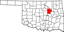 | |
| Towns | ||
| CDP | ||
| Unincorporated communities | ||
| Ghost town | ||
| Footnotes | ‡This populated place also has portions in an adjacent county or counties | |
Municipalities and communities of Tulsa County, Oklahoma, United States | ||
|---|---|---|
| Cities | 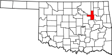 | |
| Towns | ||
| CDPs | ||
| Unincorporated community | ||
| Footnotes | ‡This populated place also has portions in an adjacent county or counties | |
| Counties | 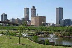 | |
|---|---|---|
| Principal city | ||
| Cities over 20k | ||
| Cities 10k-20k | ||
| Cities 5k-10k | ||
| Cities and towns 1k-5k | ||