Santa Isabel do Rio Negro
| Santa Isabel do Rio Negro | |||
|---|---|---|---|
| Municipality | |||
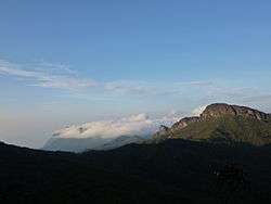 Pico da Neblina background covered by clouds, the highest point in Brazil located in the municipality, bordering Venezuela. | |||
| |||
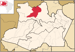 Location of the municipality inside Amazonas | |||
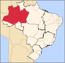
 Santa Isabel do Rio Negro Location in Brazil | |||
| Coordinates: 0°24′50″S 65°1′8″W / 0.41389°S 65.01889°WCoordinates: 0°24′50″S 65°1′8″W / 0.41389°S 65.01889°W | |||
| Country |
| ||
| Region | North | ||
| State |
| ||
| Area | |||
| • Total | 62,846 km2 (24,265 sq mi) | ||
| Population (2005) | |||
| • Total | 7,617 | ||
| Time zone | UTC−4 (BRT) | ||
| • Summer (DST) | UTC−4 (DST no longer used) | ||


Santa Isabel do Rio Negro (Saint Isabel of Black River) is a municipality located in the Brazilian state of Amazonas. Its population was 7,617 (2005) and its area is 62,846 square kilometres (24,265 sq mi).[1] The Municipality was formerly called Tapuruquara.
Pico da Neblina, the highest mountain in Brazil at 2,994 metres (9,822 feet), is located in the municipality. However, the peak is 180 kilometres (110 mi) in a straight line from the urban seat of the municipality, inaccessible except through the Amazon rainforest, and in both a national park and a Yanomami reservation under federal control and with restricted access, so this is of little to no practical significance.
The municipality also contains part of the Amazonas National Forest.[2]
The city is served by Tapuruquara Airport.
References
- ↑ IBGE -
- ↑ Unidade de Conservação: Floresta Nacional do Amazonas (in Portuguese), MMA: Ministério do Meio Ambiente, retrieved 2016-05-19
Capital: Manaus | ||||||||||||||
| Mesoregion Centro Amazonense |
|  | ||||||||||||
| Mesoregion Norte Amazonense |
| |||||||||||||
| Mesoregion Sudoeste Amazonense |
| |||||||||||||
| Mesoregion Sul Amazonense |
| |||||||||||||