Envira
| Envira | ||
|---|---|---|
| Municipality | ||
| ||
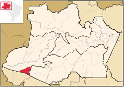 Location of the municipality inside Amazonas | ||
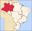
 Envira Location in Brazil | ||
| Coordinates: 7°25′58″S 70°1′22″W / 7.43278°S 70.02278°WCoordinates: 7°25′58″S 70°1′22″W / 7.43278°S 70.02278°W | ||
| Country |
| |
| Region | North | |
| State |
| |
| Time zone | UTC−4 (BRT) | |
| • Summer (DST) | UTC−4 (DST no longer used) | |

Envira is a municipality in the Brazilian state of Amazonas. Its population was 13,548 as of 2005, and its area is 13,369 km2 (5,162 sq mi).[1]
References
- ↑ IBGE - "Archived copy". Archived from the original on 2007-01-09. Retrieved 2014-08-03.
Capital: Manaus | ||||||||||||||
| Mesoregion Centro Amazonense |
|  | ||||||||||||
| Mesoregion Norte Amazonense |
| |||||||||||||
| Mesoregion Sudoeste Amazonense |
| |||||||||||||
| Mesoregion Sul Amazonense |
| |||||||||||||
This article is issued from
Wikipedia.
The text is licensed under Creative Commons - Attribution - Sharealike.
Additional terms may apply for the media files.