São Gabriel da Cachoeira
- "Uaupes" redirects here. For the river, see Vaupés River.
| São Gabriel da Cachoeira | |||
|---|---|---|---|
| Municipality | |||
| The Municipality of São Gabriel da Cachoeira | |||
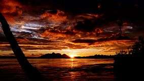 Sunset on the Hill of Six Lakes in the background in São Gabriel da Cachoeira, North of Amazonas State, Brazil. | |||
| |||
| Nickname(s): Uaupés | |||
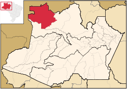 Location in the State of Amazonas | |||
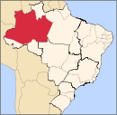
 São Gabriel da Cachoeira Location in Brazil | |||
| Coordinates: 00°07′48″N 67°05′20″W / 0.13000°N 67.08889°WCoordinates: 00°07′48″N 67°05′20″W / 0.13000°N 67.08889°W | |||
| Country |
| ||
| Region | North | ||
| State |
| ||
| Founded | September 3, 1668 | ||
| Government | |||
| • Mayor | Rene Coimbra (PCdoB) | ||
| Area | |||
| • Total | 109,185 km2 (42,157 sq mi) | ||
| Elevation | 92 m (302 ft) | ||
| Population (2008) | |||
| • Total | 40,806 | ||
| • Density | 0.31/km2 (0.8/sq mi) | ||
| [1] | |||
| Time zone | UTC-4 (AST) | ||
| HDI (2000) | 0.673 – medium[2] | ||
| Website | http://www.camarasgc.am.gov.br/ | ||
.png)
São Gabriel da Cachoeira (Saint Gabriel of the Waterfall) is a municipality located on the northern shore of the Rio Negro River, in the region of Cabeça do Cachorro, Amazonas state, Brazil.
Location
São Gabriel da Cachoeira is the third largest municipality in Brazil by territorial area, and the second largest in Amazonas. It is also the northernmost city of Amazonas, and part of its territory is within the Pico da Neblina National Park. However, the peak itself is located in Santa Isabel do Rio Negro, and São Gabriel da Cachoeira is in the lowlands. It is not far from the equator, and the climate is correspondingly hot and humid.
The city is served by São Gabriel da Cachoeira Airport.
The municipality contains the 36,900 hectares (91,000 acres) Morro dos Seis Lagos Biological Reserve, created in 1990.[3] The reserve is within the 257,000 hectares (640,000 acres) Balaio Indigenous Territory, approved in 2009.[4] The municipality also contains the 809,000 hectares (2,000,000 acres) Cué-cué/Marabitanas Indigenous Territory, declared in 2013.[5] It contains the greater part of the 7,999,000 hectares (19,770,000 acres) Alto Rio Negro Indigenous Territory, created in 1998.[6]
People
Most of the inhabitants of São Gabriel da Cachoeira are indigenous people. The city's population is somewhere around 13,000, but the entire region has 40,806 people (2008), scattered over 109,185 km2,[7] mostly indigenous peoples in surrounding tribes and villages.
Most of the non-indigenous residents of the city are affiliated with the Brazilian army, usually serving a term of two years or more.
History
The City was founded in 1668 as an aldea by Franciscan Friar Teodósio da Veiga and Captain Pedro da Costa Favela on the Rio Negro, near the mouth of the Rio Aruím. In 1761, a fort was built on the location, and the settlement became the town of São Gabriel da Cachoeira. Between 1952 and 1966, it was officially called Uaupés, after the nearby Vaupés River.
In 2003, Nheengatu became an official language along with Portuguese in São Gabriel da Cachoeira.[8]
Climate
| Climate data for São Gabriel da Cachoeira | |||||||||||||
|---|---|---|---|---|---|---|---|---|---|---|---|---|---|
| Month | Jan | Feb | Mar | Apr | May | Jun | Jul | Aug | Sep | Oct | Nov | Dec | Year |
| Average high °C (°F) | 30.8 (87.4) |
31.2 (88.2) |
31.1 (88) |
30.6 (87.1) |
29.9 (85.8) |
29.4 (84.9) |
29.4 (84.9) |
30.4 (86.7) |
31.4 (88.5) |
31.5 (88.7) |
31.3 (88.3) |
30.8 (87.4) |
30.7 (87.2) |
| Daily mean °C (°F) | 26.6 (79.9) |
26.9 (80.4) |
26.8 (80.2) |
26.6 (79.9) |
26.1 (79) |
25.6 (78.1) |
25.5 (77.9) |
26.0 (78.8) |
26.6 (79.9) |
26.9 (80.4) |
26.9 (80.4) |
26.6 (79.9) |
26.4 (79.6) |
| Average low °C (°F) | 22.5 (72.5) |
22.6 (72.7) |
22.6 (72.7) |
22.6 (72.7) |
22.4 (72.3) |
21.9 (71.4) |
21.6 (70.9) |
21.7 (71.1) |
21.9 (71.4) |
22.4 (72.3) |
22.6 (72.7) |
22.5 (72.5) |
22.3 (72.1) |
| Average precipitation mm (inches) | 273 (10.75) |
238 (9.37) |
258 (10.16) |
285 (11.22) |
317 (12.48) |
272 (10.71) |
246 (9.69) |
200 (7.87) |
176 (6.93) |
177 (6.97) |
195 (7.68) |
272 (10.71) |
2,909 (114.54) |
| Average relative humidity (%) | 78 | 78 | 75 | 75 | 78 | 78 | 77 | 73 | 72 | 71 | 72 | 76 | 75 |
| Source #1: http://en.climate-data.org/location/43904/ (temperature & precipitation) | |||||||||||||
| Source #2: http://www.tititudorancea.com/z/weather_sao_gabriel_da_cachoeira_brazil.htm (humidity) | |||||||||||||
See also
References
- ↑ IBGE 2008 statistics
- ↑ UNDP
- ↑ REBIO Morro dos Seis Lagos (in Portuguese), ISA: Instituto Socioambiental, retrieved 2017-02-23
- ↑ Terra Indígena Balaio (in Portuguese), Terras Indígenas no Brasil, retrieved 2017-02-25
- ↑ "Terra Indígena Cué-Cué/Marabitanas", Terras Indígenas no Brasil (in Portuguese), ISA: Instituto Socioambiental, retrieved 2017-02-26
- ↑ "Terra Indígena Alto Rio Negro", Terras Indígenas no Brasil (in Portuguese), ISA: Instituto Socioambiental, retrieved 2017-03-04
- ↑ IBGE -
- ↑ Larry Rohter (August 28, 2005). "Language Born of Colonialism Thrives Again in Amazon". New York Times. Retrieved December 16, 2013.
External links

Capital: Manaus | ||||||||||||||
| Mesoregion Centro Amazonense |
|  | ||||||||||||
| Mesoregion Norte Amazonense |
| |||||||||||||
| Mesoregion Sudoeste Amazonense |
| |||||||||||||
| Mesoregion Sul Amazonense |
| |||||||||||||