Sani Basantpur, Siwan
| Sani Basantpur | |
|---|---|
| Village Council | |
 Sani Basantpur Location of Goriakothi Block | |
| Coordinates: 26°15′12″N 84°36′27″E / 26.253333°N 84.6075°ECoordinates: 26°15′12″N 84°36′27″E / 26.253333°N 84.6075°E | |
| Country |
|
| State | Bihar |
| District | Siwan |
| Subdivision | Maharajganj |
| Block | Goriakothi |
| Headquarters | Maharajganj |
| Government | |
| • Lok Sabha constituency | Maharajganj |
| • Assembly seat | Goriakothi |
| Area | |
| • Total | 1.06 km2 (0.41 sq mi) |
| Elevation | 66 m (217 ft) |
| Population | |
| • Total | 4,506 |
| • Density | 4,300/km2 (11,000/sq mi) |
| Demographics | |
| • Literacy | 73% |
| • Sex ratio |
938 (Males: 2,325- 51.6%, Females: 2,181- 48.4%) |
| Time zone | UTC+5:30 (IST) |
| PIN | 841439 |
| Area code(s) | 06154 |
| Major highways | SH-73 |
Sani Basantpur is a village council situated in Goriakothi Block in Siwan district of Bihar state, India. It belongs to Saran division. It is located 21 km towards east from district headquarters Siwan and 117 km from the state capital Patna. Sani Basantpur's PIN code is 841439. Mustfabad is sub post office of Sani Basantpur. Nearby cities to Sani Basantpur is Siwan, Maharajganj, Barauli, Gopalganj and Mirganj.[1]
History
Sani basantpur, Siwan, situated in the western part of the State, was originally a sub-division of Saran District.
Geography
Situated on bank of Gandak River, one of the major rivers of Nepal and a left bank tributary of the Ganges in India.
Demographics
According to the 2011 census Sani basantpur has a population of 4506.
Village Nearby Sani basantpur
- Heyatpur
- jagdishpur
- Sangrampur
- Satwar
References
Headquarter: Siwan | ||
| Siwan Subdivision | 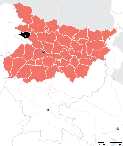 | |
| Maharajganj Subdivision | ||
| Municipalities | ||