Tha Maka District
| Tha Maka ท่ามะกา | |
|---|---|
| Amphoe | |
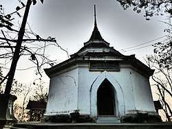 Wat Phra Thaen Dong Rang, Tha Maka | |
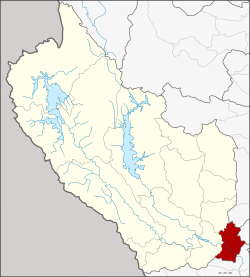 Amphoe location in Kanchanaburi Province | |
| Coordinates: 13°55′15″N 99°45′56″E / 13.92083°N 99.76556°ECoordinates: 13°55′15″N 99°45′56″E / 13.92083°N 99.76556°E | |
| Country | Thailand |
| Province | Kanchanaburi |
| Seat | Tha Maka |
| Area | |
| • Total | 340.809 km2 (131.587 sq mi) |
| Population (2005) | |
| • Total | 133,051 |
| • Density | 390.4/km2 (1,011/sq mi) |
| Time zone | UTC+7 (ICT) |
| Postal code | 71120 |
| Geocode | 7105 |
Tha Maka (Thai: ท่ามะกา, pronounced [tʰâː má.kāː]) is the southeasternmost district (amphoe) of Kanchanaburi Province, central Thailand.
Geography
Neighboring districts are (from the west clockwise) Tha Muang, Phanom Thuan of Kanchanaburi Province, Song Phi Nong of Suphanburi Province, Kamphaeng San of Nakhon Pathom Province, and Ban Pong of Ratchaburi Province.
The important water resource is the Mae Klong River.
History
Tha Maka was originally part of Ratchaburi Province, and named Lat Bua Khao (ลาดบัวขาว). In 1903 it was renamed Phra Thaen (พระแท่น),[1] In 1917 it received its current name, Tha Maka.[2] In 1937 the district was reassigned to Kanchanaburi, with only the sub-district Lat Bua Khao changed to Ban Pong and remaining in Ratchaburi.[3]
Administration
The district is divided into 17 sub-districts (tambon), which are further subdivided into 153 villages (muban). Tha Ruea Phra Thaen is a town (thesaban mueang) and covers the whole tambon Tha Ruea and parts of Takhram En. There are five townships (thesaban tambon) in the district. There are 15 tambon administrative organizations (TAO).
| No. | Name | Thai name | Villages | Pop. | |
|---|---|---|---|---|---|
| 1. | Phong Tuek | พงตึก | 6 | 4,228 | |
| 2. | Yang Muang | ยางม่วง | 9 | 6,384 | |
| 3. | Don Cha-em | ดอนชะเอม | 10 | 6,675 | |
| 4. | Tha Mai | ท่าไม้ | 10 | 9,847 | |
| 5. | Takhram En | ตะคร้ำเอน | 16 | 19,160 | |
| 6. | Tha Maka | ท่ามะกา | 11 | 14,624 | |
| 7. | Tha Ruea | ท่าเรือ | - | 6,622 | |
| 8. | Khok Tabong | โคกตะบอง | 8 | 4,139 | |
| 9. | Don Khamin | ดอนขมิ้น | 9 | 8,781 | |
| 10. | Ulok Si Muen | อุโลกสี่หมื่น | 8 | 6,799 | |
| 11. | Khao Samsip Hap | เขาสามสิบหาบ | 8 | 5,956 | |
| 12. | Phra Thaen | พระแท่น | 16 | 8,994 | |
| 13. | Wai Niao | หวายเหนียว | 7 | 6,322 | |
| 14. | Saen To | แสนตอ | 12 | 8,037 | |
| 15. | Sanam Yae | สนามแย้ | 7 | 7,055 | |
| 16. | Tha Sao | ท่าเสา | 8 | 5,043 | |
| 17. | Nong Lan | หนองลาน | 8 | 4,385 |
References
- ↑ แจ้งความกระทรวงมหาดไทย เรื่อง เปลี่ยนนามอำเภอลาดบัวขาย แขวงเมืองราชบุรี เป็นอำเภอพระแท่น (PDF). Royal Gazette (in Thai). 20 (28): 460. October 11, 1903.
- ↑ ประกาศกระทรวงมหาดไทย เรื่อง เปลี่ยนชื่ออำเภอ (PDF). Royal Gazette (in Thai). 34 (0 ก): 40–68. April 29, 1917.
- ↑ พระราชบัญญัติเปลี่ยนแปลงเขตจังหวัด พุทธศักราช ๒๔๗๙ (PDF). Royal Gazette (in Thai). 54 (0 ก): 40–54. April 1, 1937.
External links
- http://www.thamaka.com Website of district
- amphoe.com
 | ||