Sanana Island
 | |
| Geography | |
|---|---|
| Location | South East Asia |
| Coordinates | 2°12′00″S 125°55′00″E / 2.2°S 125.91667°E |
| Archipelago | Maluku Islands |
| Area | 532.3 km2 (205.5 sq mi) |
| Administration | |
|
Indonesia | |
| Largest settlement | Sanana |
| Demographics | |
| Population | 48,892 (2010 Census) |
| Pop. density | 91.85 /km2 (237.89 /sq mi) |
Sanana or Sula Besi Island (earlier name Xulla Besi [1]) is an island, part of Sula Islands which is part of North Maluku province in Indonesia. Sanama is also the name of that island's largest settlement, home to the Dutch era fort Benteng De Verwachting.[2][3]
Districts
The island is divided into six districts within the Sula Islands Regency, which are set out below with their reas and the populations at the 2010 Census.[4]
| Name | English name | Area in sq.km | Population Census 2010 |
|---|---|---|---|
| Sanana Utara | North Sanana | 75.28 | 5,675 |
| Sanana | Sanama town | 83.36 | 25,183 |
| Sula Besi Tengah | Central Sula Besi | 74.73 | 5,929 |
| Sula Besi Timur | East Sula Besi | 82.18 | 3,100 |
| Sula Besi Selatan | South Sula Besi | 88.49 | 4,298 |
| Sula Besi Barat | West Sula Besi | 128.26 | 4,707 |
| Sula Besi Island | (total) | 532.30 | 48,892 |
Gallery
 Men and children on the beach (1930-1936)
 Fort de Verwachtingh in 1921
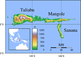
Sanana is located at 2°12′00″S 125°55′00″E / 2.2°S 125.916667°ECoordinates: 2°12′00″S 125°55′00″E / 2.2°S 125.916667°E, south of Mangole Island. The area of the island is 558 km².
Sanana airport is linked to Ambon by Trigana Air Service flights.[5]
As was common throughout Maluku at that time, Sanana suffered serious religio-ethnic tensions between Muslims and Christians during 1999.
References
| Wikimedia Commons has media related to Sanana. |
- ↑ Goodall, George (Editor)(1943) Philips' International Atlas London, George Philip and Son map 'East Indies' pp.91-92
- ↑ Lonely Planet; Ryan Ver Berkmoes; Celeste Brash; Muhammad Cohen; Mark Elliott; Guyan Mitra; John Noble; Adam Skolnick; Iain Stewart; Steve Waters (2010). Lonely Planet Indonesia. Lonely Planet Publications. p. 741. ISBN 978-1-74104-830-8.
- ↑ Photo of Sanana's fort before 1920
- ↑ Biro Pusat Statistik, Jakarta, 2011.
- ↑ "Trigana Air Service". Trigana-air.com. Retrieved 2013-12-01.
- ^ Ambon rioting leaves 100 dead in Indonesia from World Socialist Website, 30 January 1999