Mangole Island
 | |
| Geography | |
|---|---|
| Location | South East Asia |
| Coordinates | 1°48′S 125°48′E / 1.8°S 125.8°E |
| Archipelago | Maluku Islands |
| Administration | |
|
Indonesia | |
| Demographics | |
| Population | 36,323 (2010 Census) |
| Pop. density | 28.9 /km2 (74.9 /sq mi) |
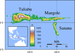
Mangole (Xulla Mangola - earlier name.[1]) is a large island in the Sula Islands, which again are part of North Maluku province in Indonesia. It is located at 1°48′S 125°48′E / 1.8°S 125.8°E, east of Taliabu Island and north of Sanana Island. It has an area of 1,255.33 sq.km. At the 2010 Census, 36,323 people lived on the island of Mangole. Its economy is dominated by the timber industry.
Districts
The island is divided into six districts within the Sula Islands Regency, listed below with their areas and populations at the 2010 Census[2].
| Name | English name | Area in sq.km | Population Census 2010 |
|---|---|---|---|
| Mangole Barat | West Mangole | 158.30 | 7,084 |
| Mangole Utara | North Mangole | 227.61 | 10,115 |
| Mangole Selatan | South Mangole | 246.56 | 4,665 |
| Mangole Tengah | Central Mangole | 333.21 | 6,381 |
| Mangole Timur | East Mangole | 140.42 | 4,301 |
| Mangole Utara Timur | Northeast Mangole | 149.23 | 3,777 |
| Mangole Island | (total) | 1,255.33 | 36,323 |
Notes
- ^ Asia-Pacific Quake rocks Indonesian islands from BBC News, 30 November 1998
This article is issued from
Wikipedia.
The text is licensed under Creative Commons - Attribution - Sharealike.
Additional terms may apply for the media files.