San José Province
| San José | |||
|---|---|---|---|
| Province | |||
| |||
 | |||
| Coordinates: 9°36′N 83°57′W / 9.6°N 83.95°WCoordinates: 9°36′N 83°57′W / 9.6°N 83.95°W | |||
| Country | Costa Rica | ||
| Capital city | San José (pop. 1,274,746) | ||
| Area | |||
| • Total | 4,966 km2 (1,917 sq mi) | ||
| Population (2011) | |||
| • Total | 1,404,242 | ||
| • Density | 280/km2 (730/sq mi) | ||
| ISO 3166 code | CR-SJ | ||


Blanco River, county of Pérez Zeledón. Most rivers in the province of San José are shallow, narrow and often run through mountainous terrain, making them impossible to navigate.

Cerro de la Muerte, southeast of the province
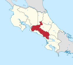
San José (Spanish pronunciation: [saŋ xoˈse]) is a province of Costa Rica. It is located in the central part of the country, and borders (clockwise beginning in the north) the provinces of Alajuela, Heredia, Limón, Cartago and Puntarenas. The provincial and national capital is San José. The province covers an area of 4,965.9 km².[1] and has a population of 1,404,242.[2]
Subdivision
The province of San José is subdivided into 20 cantons.
Canton (Capital):
- San José (San José)
- Escazú (Escazú)
- Desamparados (Desamparados)
- Puriscal (Santiago)
- Tarrazú (San Marcos)
- Aserrí (Aserrí)
- Mora (Ciudad Colón)
- Goicoechea (Guadalupe)
- Santa Ana (Santa Ana)
- Alajuelita (Alajuelita)
- Vázquez de Coronado (San Isidro)
- Acosta (San Ignacio)
- Tibás (San Juan)
- Moravia (San Vicente)
- Montes de Oca (San Pedro)
- Turrubares (San Pablo)
- Dota (Santa María)
- Curridabat (Curridabat)
- Pérez Zeledón (San Isidro de El General)
- León Cortés (San Pablo)
See also
References
- ↑ Instituto Geográfico Nacional (IGN), 2001,
- ↑ Resultados Generales Censo 2011 Archived 2012-10-21 at the Wayback Machine. p. 22
External links
![]()
This article is issued from
Wikipedia.
The text is licensed under Creative Commons - Attribution - Sharealike.
Additional terms may apply for the media files.