Saltney
| Saltney | |
|---|---|
 Saltney High Street | |
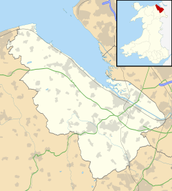 Saltney Saltney shown within Flintshire | |
| Population | 5,132 (2011 Census) |
| OS grid reference | SJ375645 |
| Principal area | |
| Ceremonial county | |
| Country | Wales |
| Sovereign state | United Kingdom |
| Post town | CHESTER |
| Postcode district | CH4 |
| Dialling code | 01244 |
| Police | North Wales |
| Fire | North Wales |
| Ambulance | Welsh |
| EU Parliament | Wales |
| UK Parliament | |
| Welsh Assembly | |
| Saltney | |
|---|---|
| Unitary authority | |
| Ceremonial county | |
| Region | |
| Country | England |
| Sovereign state | United Kingdom |
| Police | Cheshire |
| Fire | Cheshire |
| Ambulance | North West |
| EU Parliament | North West England |
| UK Parliament | |
Saltney is a town and community adjoining Chester on the England–Wales border with the west part lying in Flintshire and the eastern part in Cheshire. It is part of the Deeside conurbation of towns that lie near the River Dee.
Location
Higher Saltney, known locally as "Top Saltney" (part of the area known locally as Saltney) is in Chester, Cheshire, and the Welsh sector of the community is known as Saltney Town.[1] The English-Welsh border runs down the middle of Boundary Lane in Saltney, the only urban street in England and Wales where this happens.[2] Houses on the west side of the street are in the Flintshire County Council area and in the North Wales Police jurisdiction, while those on the east side are in the Cheshire West and Chester unitary authority area and in the Cheshire Police jurisdiction.[2] register. The west side is in the Alyn and Deeside parliamentary constituency and the east is in the City of Chester electoral division.
History
Saltney's name is derived from the former salt marshes by the River Dee on which it is built. Once the terminus of Sir John Glynne's Canal, Saltney grew in the late-19th century and through the 20th century to its present population of 4,769 at the 2001 census.[3] Saltney Ferry railway station was open between 1891 and 1962.
Amenities
There is a public house called The City Arms in Higher Saltney. Hanging outside was a sign "The Last Pub In England" and on the other side it read "The First Pub In England". This sign was taken down some years ago. Other amenities in Saltney include the Corner Pin public house, a post office, Saltney Business Centre, St David's Retail Park (Farmfoods/Poundstretchers/Ableworld/WizzKidz), an Asda supermarket (formerly a Netto store) and a Morrisons supermarket.
Saltney has 3 primary schools, St Anthony's Catholic Primary, Saltney Ferry C.P and Wood Memorial. St David's High School is the local secondary school for students from the surrounding areas.
The Anglican parish church is St Mark's which is in Higher Saltney. On the High Street can be found St Anthony of Padua Catholic Church and Saltney Methodist Church.
There is a community centre in the centre of Saltney which is regularly used by children's groups as well as being surrounded by fields where football tournaments are often held (weather permitting). The Community Centre is also home to Saltney Town FC who formed in 2010.
See also
- St Matthew's Church, Saltney
- Llanymynech, a village straddling the border between Montgomeryshire/Powys, Wales and Shropshire, England
- Sealand, Flintshire, a nearby area of farmland reclaimed from the Dee estuary.
- Chester Corporation Tramways former tramway to Chester station
References
- ↑ Lache Park (Ward Profile) (PDF), Chester City Council, archived from the original (PDF) on 10 November 2008, retrieved 30 November 2007
- 1 2 The One Show, BBC TV, 6 August 2009
- ↑ 2001 Census: Saltney, Office for National Statistics, retrieved 30 November 2007
External links
| Wikimedia Commons has media related to Saltney. |
Cheshire Portal | |
| Unitary authorities | |
| Major settlements | |
| Rivers | |
| Topics | |