Holywell, Flintshire
Holywell
| |
|---|---|
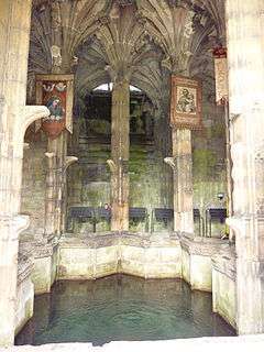 St Winefride's Well, Holywell | |
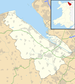 Holywell Holywell shown within Flintshire | |
| Population | 8,886 (2011 Census)[1] |
| OS grid reference | SJ185755 |
| Principal area | |
| Ceremonial county | |
| Country | Wales |
| Sovereign state | United Kingdom |
| Post town | HOLYWELL |
| Postcode district | CH8 |
| Dialling code | 01352 |
| Police | North Wales |
| Fire | North Wales |
| Ambulance | Welsh |
| EU Parliament | Wales |
| UK Parliament | |
| Welsh Assembly | |
Holywell (Welsh: Treffynnon) is the fifth largest town and a community in Flintshire, Wales. It lies to the west of the estuary of the River Dee. The community includes Greenfield.
History
The market town of Holywell takes its name from the St Winefride's Well, a holy well surrounded by a chapel.[2] The well has been known since at least the Roman period. It has been a site of Christian pilgrimage since about 660, dedicated to Saint Winefride who, according to legend, was beheaded there by Caradog who attempted to attack her.[3][4] The well is one of the Seven Wonders of Wales and the town bills itself as The Lourdes of Wales. Many pilgrims from all over the world continue to visit Holywell and the Well.
From the 18th century, the town grew around the lead mining and cotton milling industries. The water supply from the mountains above the town, which flows continually and at a constant temperature, supplies the well and powered many factories in the Greenfield Valley. In addition to lead and cotton, copper production was of great importance. Thomas Williams, a lawyer from Anglesey, built factories and smelteries for copper in Greenfield Valley, bringing the copper from Anglesey to St. Helens and then to Greenfield Valley where it was used to make many items for the slave trade. These items included manilas (copper bracelets), neptunes (large flat dishes to evaporate seawater to produce salt) and copper sheathing. The copper sheathing was used to cover the hulls of the wooden ships trading in the warmer Caribbean waters, giving rise to the expression 'copper bottomed investment', the sheathing was also applied to Royal Navy ships and was instrumental in Nelson's victories (two of these copper plates from HMS Victory are in Greenfield Valley Heritage Park museum). There was a railway station in Greenfield that was open between 1848 and 1966. Holywell Town station, at the head of a steeply-climbing branch from Holywell Junction, was closed in 1957.
The wealth generated from these industries led to the development of the town and the High Street still has many Georgian buildings. The Greenfield Valley is well known for the abundance of birds and butterflies and many enthusiasts visit to see the array of species. The Valley also has a number of conserved mills and structures from bygone ages and is the only place in Wales to have seven scheduled ancient monuments.
.jpg)
St James parish church is a grade II* listed building.[5]
Holywell hosted an unofficial National Eisteddfod event in 1869.
Demography
Administratively, Holywell town consists of three wards of the Flintshire County Council local authority. At the 2001 Census, the total population of the town was:
| Ward | Population |
|---|---|
| Holywell Central | 1,835 [6] |
| Holywell East | 1,828 [7] |
| Holywell West | 2,311 [8] |
| Holywell Total | 5,974 |
With the adjoining villages including Greenfield, Whitford and Carmel the population of the area is over 15,000.
Railways
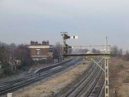
Holywell Junction was on the North Wales Coast Line. The station is closed, and trains run fast through what remains of the station. The station building, by Francis Thompson for the Chester and Holyhead Railway (1848), is listed Grade II*. The LNWR branch line from here to Holywell Town, opened in 1912 and finally closed in 1957.
Geography
Holywell is split into four distinct areas: Pen-y-Maes, the Strand, the Holway and the town centre. The Holway, located on the west side of the town, is the largest of the residential areas of Holywell. The near-contiguous village of Greenfield is located to the north east of the town on the B5121 road.
Villages within the Holywell catchment area include: Bagillt, Brynford, Carmel, Gorsedd, Halkyn, Licswm, Lloc, Mostyn, Pantasaph, Pentre Halkyn, Rhes-y-Cae, Trelawnyd, Whitford and Ysceifiog. In addition there are other smaller scattered communities within this area. All of these are within a six-mile radius of Holywell. These villages are all connected to Holywell by a frequent bus service.[9]
Community
The town centre contains many small businesses and national stores, serving not only the shopping needs of the people of the town itself, but also those of the surrounding villages within the town's natural catchment area. Part of the centre of the historic market town has been designated a conservation area.[10]
The town contains a secondary school with over 500 pupils and a leisure centre, as well as four primary schools.
Holywell has a local football team, Holywell Town who play in the Welsh Alliance League.
The old cottage hospital was located in Pen-y-Maes until it closed. A new hospital has been built.
Although Holywell does not have a cricket team carrying the name of the town; a number of junior and senior cricketers from the area play for nearby village team Carmel & District Cricket Club whose ground is located a short distance from Holywell between the villages of Carmel and Lloc.
In 2007, a group of locals proposed a circular walk way, the "St Beuno's Circular Walk", joining all of the historical and religious locations of the town.[11]
Notable people
- Charles Sidney Beauclerk, Catholic priest who led the revival of the town as a pilgrimage centre.
- Ian Buckett, Wales rugby player, born near here and attended school in Holywell.
- Former Southampton and Wales footballer Ron Davies was born in Holywell in 1942.
- Former England footballer Gerry Hitchens, after retiring from professional play, lived at Holywell from 1977 and is buried there.
- Mike England, Wales footballer and football manager, was born in Holywell in 1941.
- Television presenter Gareth Jones (Gaz Top) comes from Holywell.
- Thomas Pennant (14 June O.S. 1726 – 16 December 1798) was a Welsh naturalist, traveller, writer and antiquarian. He lived his at his family estate, Downing Hall near Whitford.
- Jonathan Pryce, actor, was born in Holywell in 1947.
- Emlyn Williams, dramatist and actor, attended Holywell Grammar School.
- Sir Ronald Waterhouse, High Court judge.
- Richard and Adam Johnson, classical singers.
- Barry Horne, Footballers for Wales and Everton.
See also
References
- ↑ "Town population 2011". Retrieved 25 May 2015.
- ↑ About Holywell, Holywell Town Website, archived from the original on 10 June 2002, retrieved 3 August 2009
- ↑

- ↑
- ↑ "Parish Church of St.james,greenfield Street, Holywell". British Listed Buildings. Retrieved 9 January 2014.
- ↑ Ward Profile: Holywell Central (PDF), Flintshire County Council, retrieved 13 November 2007
- ↑ Ward Profile: Holywell East (PDF), Flintshire County Council, retrieved 13 November 2007
- ↑ Ward Profile: Holywell West (PDF), Flintshire County Council, retrieved 13 November 2007
- ↑ Business Profile of Holywell, retrieved 28 March 2009
- ↑ Flintshire Conservation Areas, Flintshire County Council, retrieved 3 August 2009
- ↑ Proposed St Bueno's Circular Walk, retrieved 10 May 2007
External links
| Wikimedia Commons has media related to Holywell. |
| Wikisource has the text of the 1905 New International Encyclopedia article Holywell, Flintshire. |
- Shrine website
- Holywell website
- BBC Wales: Holywell
- Photos of Holywell and surrounding area on geograph.org.uk
- Things to do in Holywell