Saloma, Kentucky
| Saloma | |
|---|---|
| Unincorporated community | |
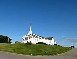 Saloma Baptist Church | |
 Saloma Location within the state of Kentucky  Saloma Saloma (the US) | |
| Coordinates: 37°24′43″N 85°23′34″W / 37.41194°N 85.39278°WCoordinates: 37°24′43″N 85°23′34″W / 37.41194°N 85.39278°W | |
| Country | United States |
| State | Kentucky |
| County | Taylor |
| Elevation | 906 ft (276 m) |
| Time zone | UTC-5 (Eastern (EST)) |
| • Summer (DST) | UTC-4 (EDT) |
| GNIS feature ID | 502817 |
Saloma is an unincorporated community in Taylor County, Kentucky, United States. It lies along Routes 527 and 744 northwest of the city of Campbellsville, the county seat of Taylor County.[1] Its elevation is 906 feet (276 m).[2]
Saloma was established in 1838, and had its own post office during the 19th century. The origin of the name "Saloma" is unknown.[3]
References
- ↑ Rand McNally. The Road Atlas '06. Chicago: Rand McNally, 2006, p. 42.
- ↑ U.S. Geological Survey Geographic Names Information System: Saloma, Kentucky, Geographic Names Information System, 1979-09-20. Accessed 2007-12-31.
- ↑ Rennick, Robert M. (1987). Kentucky Place Names. University Press of Kentucky. p. 262. Retrieved 2017-07-17.
Municipalities and communities of Taylor County, Kentucky, United States | ||
|---|---|---|
| City | 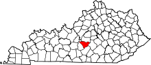 | |
| Unincorporated communities | ||
This article is issued from
Wikipedia.
The text is licensed under Creative Commons - Attribution - Sharealike.
Additional terms may apply for the media files.