Salem, Utah
| Salem, Utah | |
|---|---|
| City | |
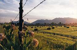 A partial view of Utah Valley seen here from outside of Salem | |
| Nickname(s): City of peace | |
| Motto(s): Making Life Better | |
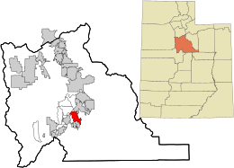 Location in Utah County and the state of Utah | |
| Coordinates: 40°3′2″N 111°40′21″W / 40.05056°N 111.67250°WCoordinates: 40°3′2″N 111°40′21″W / 40.05056°N 111.67250°W | |
| Country | United States |
| State | Utah |
| County | Utah |
| Settled | 1851 |
| Incorporated | May 10, 1920 |
| Named for | Salem, Massachusetts |
| Government | |
| • Type | Strong Mayor Municipal Format |
| • Mayor | Kurt Christensen |
| Area | |
| • Total | 10.2 sq mi (26.4 km2) |
| • Land | 10.2 sq mi (26.3 km2) |
| • Water | 0.04 sq mi (0.1 km2) |
| Elevation | 4,610 ft (1,405 m) |
| Population (2017) | |
| • Total | 8,210[1] |
| • Density | 805/sq mi (311/km2) |
| Time zone | UTC-7 (Mountain (MST)) |
| • Summer (DST) | UTC-6 (MDT) |
| ZIP code | 84653 |
| Area code(s) | 385, 801 |
| FIPS code | 49-65770[2] |
| GNIS feature ID | 1445262[3] |
| Website | Salem City |
Salem is a city in Utah County, Utah, United States. It is part of the Provo–Orem Metropolitan Statistical Area. The population was 6,423 at the 2010 census.[4] The "Dream Mine" of John Hyrum Koyle, as well as the pond, became synonymous with Salem.
History
Known as "Summer Spring" by the Indians, and "Pond Town" by early settlers. Pond Town was first settled in 1851.
Salem was later named after New Salem, Massachusetts, the birthplace of Lyman Curtis, to honor his contributions to the community.[5] Curtis was known to be good with a gun, and was a bodyguard for the prophet Joseph Smith. He was a member of Zions Camp. He also was in the discovery party of nine riders that first rode on horseback into the Salt Lake Valley in July 1847. He was not officially recognized as one of the nine riders. The other eight have been recognized, though the ninth rider is stated to be unknown. Lyman Curtis also was chosen to develop water irrigation canals into Moapa, Nevada, St. George, Utah, Price, Utah, and Salem, bringing water out of the Spanish Fork Canyon. He built a lumber facility in Salem, and the front door of the lumber business is currently on the cabin in Salem dedicated to the Daughters of Utah Pioneers. His son became a medical doctor known as Doc Curtis who delivered babies, and other medical necessities to residents, several of the current older residents of Salem remember well.[6]
Geography
According to the United States Census Bureau, the city has a total area of 10.2 square miles (26.4 km2), of which 10.2 square miles (26.3 km2) is land and 0.04 square miles (0.1 km2), or 0.23%, is water.[7]
Climate
This climatic region is typified by large seasonal temperature differences, with warm to hot (and often humid) summers and cold (sometimes severely cold) winters. According to the Köppen Climate Classification system, Salem has a humid continental climate, abbreviated "Dfb" on climate maps.[8]
Demographics
| Historical population | |||
|---|---|---|---|
| Census | Pop. | %± | |
| 1860 | 179 | — | |
| 1870 | 353 | 97.2% | |
| 1880 | 510 | 44.5% | |
| 1890 | 527 | 3.3% | |
| 1900 | 894 | 69.6% | |
| 1910 | 693 | −22.5% | |
| 1920 | 609 | −12.1% | |
| 1930 | 610 | 0.2% | |
| 1940 | 659 | 8.0% | |
| 1950 | 781 | 18.5% | |
| 1960 | 920 | 17.8% | |
| 1970 | 1,081 | 17.5% | |
| 1980 | 2,233 | 106.6% | |
| 1990 | 2,284 | 2.3% | |
| 2000 | 4,372 | 91.4% | |
| 2010 | 6,423 | 46.9% | |
| Est. 2017 | 8,210 | [9] | 27.8% |
| U.S. Decennial Census[10] | |||
As of the census[2] of 2000, there were 4,372 people, 1,128 households, and 1,009 families residing in the city. The population density was 825.0 people per square mile (318.5/km²). There were 1,166 housing units at an average density of 220.0 per square mile (84.9/km²). The racial makeup of the city was 97.07% White, 0.07% African American, 0.09% Native American, 0.14% Asian, 0.27% Pacific Islander, 1.40% from other races, and 0.96% from two or more races. Hispanic or Latino of any race were 2.79% of the population.
There were 1,128 households out of which 56.0% had children under the age of 18 living with them, 82.3% were married couples living together, 5.1% had a female householder with no husband present, and 10.5% were non-families. 9.7% of all households were made up of individuals and 5.1% had someone living alone who was 65 years of age or older. The average household size was 3.86 and the average family size was 4.14.
In the city, the population was spread out with 40.6% under the age of 18, 10.2% from 18 to 24, 25.0% from 25 to 44, 16.4% from 45 to 64, and 7.8% who were 65 years of age or older. The median age was 24 years. For every 100 females, there were 102.3 males. For every 100 females age 18 and over, there were 98.2 males.
The median income for a household in the city was $54,813, and the median income for a family was $57,557. Males had a median income of $40,116 versus $22,798 for females. The per capita income for the city was $16,507. About 3.1% of families and 4.1% of the population were below the poverty line, including 5.2% of those under age 18 and 5.7% of those age 65 or over.
Education
Public schools in Salem are part of the Nebo School District. Salem has three elementary schools, one junior high school, and one high school. Rick Nielsen is the Superintendent of Schools.[11]
Salem Days
Salem Days is a week-long city celebration held in either the first or second week of August every year and are a collective of many activities, including a baby contest, car show, cardboard boat regatta, grand parade, firework show, pageant, children's parade, and movie in the park. It has been going on since 1949 when the LDS church asked the cities of Utah to celebrate their towns yearly.
Fun facts
- The 2013 Utah Driver's Handbook Cover was a scenic picture of Salem.
- At the foothills of Tower Mountain can be found hieroglyphics showing several animals (goats or sheep) carrying packs, on a rock wall.
- Salem was incorporated as a town in 1886, and fourteen presidents and boards of trustees served until 1920, at which time the first mayor began his term in office.
See also
References
- ↑ https://www.census.gov/quickfacts/fact/table/salemcityutah,utahcountyutah,provocityutah/PST045216
- 1 2 "American FactFinder". United States Census Bureau. Retrieved January 31, 2008.
- ↑ "US Board on Geographic Names". United States Geological Survey. October 25, 2007. Retrieved January 31, 2008.
- ↑ "Profile of General Population and Housing Characteristics: 2010 Demographic Profile Data (DP-1): Salem city, Utah". U.S. Census Bureau, American Factfinder. Retrieved March 8, 2012.
- ↑ Arlene Despain Wilson. "Short History of Salem". Retrieved March 28, 2011.
- ↑ Personal history of Lyman Curtis
- ↑ "Geographic Identifiers: 2010 Demographic Profile Data (G001): Salem city, Utah". U.S. Census Bureau, American Factfinder. Retrieved March 8, 2012.
- ↑ Climate Summary for Salem, Utah
- ↑ "Population and Housing Unit Estimates". Retrieved June 9, 2017.
- ↑ "Census of Population and Housing". Census.gov. Retrieved June 4, 2015.
- ↑ "Nebo School District". Nebo School District. Retrieved June 17, 2012.
External links
| Wikimedia Commons has media related to Salem, Utah. |
- Official website
- Koyle Relief Mine map, MSS 8030 at L. Tom Perry Special Collections, Brigham Young University. Map of Salem's "Dream Mine."
Places adjacent to Salem, Utah | |
|---|---|
Municipalities and communities of Utah County, Utah, United States | ||
|---|---|---|
| Cities | 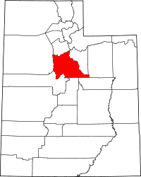 | |
| Towns | ||
| CDPs | ||
| Unincorporated communities | ||
| Indian reservation | ||
| Ghost towns | ||
| Footnotes | ‡This populated place also has portions in an adjacent county or counties | |