Sainte-Hélène-de-Kamouraska, Quebec
| Sainte-Hélène-de-Kamouraska | |
|---|---|
| Municipality | |
 | |
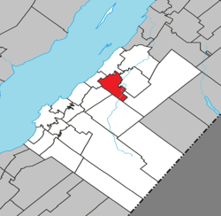 Location within Kamouraska RCM | |
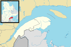 Sainte-Hélène-de-Kamouraska Location in eastern Quebec | |
| Coordinates: 47°36′N 69°44′W / 47.600°N 69.733°WCoordinates: 47°36′N 69°44′W / 47.600°N 69.733°W[1] | |
| Country |
|
| Province |
|
| Region | Bas-Saint-Laurent |
| RCM | Kamouraska |
| Constituted | July 1, 1855 |
| Government[2] | |
| • Mayor | Louise Hémond |
| • Federal riding | Montmagny—L'Islet—Kamouraska—Rivière-du-Loup |
| • Prov. riding | Côte-du-Sud |
| Area[2][3] | |
| • Total | 60.60 km2 (23.40 sq mi) |
| • Land | 60.71 km2 (23.44 sq mi) |
| There is an apparent contradiction between two authoritative sources | |
| Population (2011)[3] | |
| • Total | 911 |
| • Density | 15.0/km2 (39/sq mi) |
| • Pop 2006-2011 |
|
| • Dwellings | 391 |
| Time zone | UTC−5 (EST) |
| • Summer (DST) | UTC−4 (EDT) |
| Postal code(s) | G0L 3J0 |
| Area code(s) | 418 and 581 |
| Highways |
|
| Website |
sainte-helene |
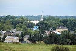
Sainte-Hélène-de-Kamouraska is a municipality in the Canadian province of Quebec, located in the Kamouraska Regional County Municipality.
Until September 13, 2014 it was officially known simply as Sainte-Hélène.[4]
Municipal council
- Mayor: Vacancy
- Councillors: Blaise Bérubé, Daniel Lajoie, Jacques Laplante, Joël Moreau, Jacques St-Pierre, plus a vacancy
See also
References
- ↑ Reference number 398140 of the Commission de toponymie du Québec (in French)
- 1 2 Geographic code 14025 in the official Répertoire des municipalités (in French)
- 1 2 "(Code 2414025) Census Profile". 2011 census. Statistics Canada. 2012.
- ↑ "Modifications aux municipalités du Québec" (PDF). Institut de la statistique du Québec. September 2014. ISSN 1715-6408.
External links

Adjacent Municipal Subdivisions | ||||||||||
|---|---|---|---|---|---|---|---|---|---|---|
| ||||||||||
| Cities & Towns | |
|---|---|
| Municipalities | |
| Parishes | |
| Unorganized territories | |
| |
This article is issued from
Wikipedia.
The text is licensed under Creative Commons - Attribution - Sharealike.
Additional terms may apply for the media files.