Picard, Quebec
| Picard | |
|---|---|
| Unorganized territory | |
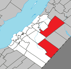 Location within Kamouraska RCM | |
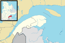 Picard Location in eastern Quebec | |
| Coordinates: 47°30′N 69°31′W / 47.500°N 69.517°WCoordinates: 47°30′N 69°31′W / 47.500°N 69.517°W[1] | |
| Country |
|
| Province |
|
| Region | Bas-Saint-Laurent |
| RCM | Kamouraska |
| Government[2] | |
| • Federal riding | Montmagny—L'Islet—Kamouraska—Rivière-du-Loup |
| • Prov. riding | Côte-du-Sud |
| Area[2][3] | |
| • Total | 572.20 km2 (220.93 sq mi) |
| • Land | 567.69 km2 (219.19 sq mi) |
| Population (2011)[3] | |
| • Total | 5 |
| • Density | 0/km2 (0/sq mi) |
| • Pop 2006-2011 |
|
| • Dwellings | 10 |
| Time zone | UTC−5 (EST) |
| • Summer (DST) | UTC−4 (EDT) |
| Highways |
|
Picard is an unorganized territory in the Canadian province of Quebec, located in the Kamouraska Regional County Municipality. The territory consists of two non-contiguous areas.
See also
References
North-eastern part | |
|---|---|
South-western part | |
|---|---|
| Cities & Towns | |
|---|---|
| Municipalities | |
| Parishes | |
| Unorganized territories | |
| |
This article is issued from
Wikipedia.
The text is licensed under Creative Commons - Attribution - Sharealike.
Additional terms may apply for the media files.