Sainte-Cécile-de-Lévrard, Quebec
| Sainte-Cécile-de-Lévrard | |
|---|---|
| Parish municipality | |
 | |
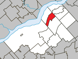 Location within Bécancour RCM | |
 Ste-Cécile-de-Lévrard Location in southern Quebec | |
| Coordinates: 46°28′N 72°10′W / 46.47°N 72.17°WCoordinates: 46°28′N 72°10′W / 46.47°N 72.17°W[1] | |
| Country |
|
| Province |
|
| Region | Centre-du-Québec |
| RCM | Bécancour |
| Constituted | September 11, 1908 |
| Government[2] | |
| • Mayor | Simon Brunelle |
| • Federal riding |
Bas-Richelieu— Nicolet—Bécancour |
| • Prov. riding | Nicolet-Bécancour |
| Area[2][3] | |
| • Total | 32.20 km2 (12.43 sq mi) |
| • Land | 32.32 km2 (12.48 sq mi) |
|
There is an apparent contradiction between two authoritative sources | |
| Population (2011)[3] | |
| • Total | 362 |
| • Density | 11.2/km2 (29/sq mi) |
| • Pop 2006-2011 |
|
| • Dwellings | 162 |
| Time zone | UTC−5 (EST) |
| • Summer (DST) | UTC−4 (EDT) |
| Postal code(s) | G0X 2M0 |
| Area code(s) | 819 |
| Highways |
|
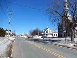
Sainte-Cécile-de-Lévrard is a parish municipality in the Centre-du-Québec region of the province of Quebec in Canada.
See also
References
External links

Adjacent Municipal Subdivisions | ||||||||||
|---|---|---|---|---|---|---|---|---|---|---|
| ||||||||||
| Cities | |
|---|---|
| Municipalities | |
| Parishes | |
| |
This article is issued from
Wikipedia.
The text is licensed under Creative Commons - Attribution - Sharealike.
Additional terms may apply for the media files.