Saint-Pierre-les-Becquets, Quebec
| Saint-Pierre-les-Becquets | |
|---|---|
| Municipality | |
 | |
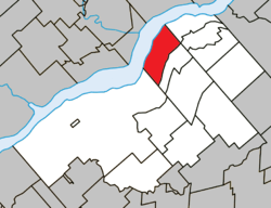 Location within Bécancour RCM | |
 St-Pierre-les-Becquets Location in southern Quebec | |
| Coordinates: 46°30′N 72°12′W / 46.5°N 72.2°WCoordinates: 46°30′N 72°12′W / 46.5°N 72.2°W[1] | |
| Country |
|
| Province |
|
| Region | Centre-du-Québec |
| RCM | Bécancour |
| Constituted | February 22, 1986 |
| Government[2] | |
| • Mayor | Jean-Guy Paré |
| • Federal riding |
Bas-Richelieu— Nicolet—Bécancour |
| • Prov. riding | Nicolet-Bécancour |
| Area[2][3] | |
| • Total | 65.10 km2 (25.14 sq mi) |
| • Land | 47.74 km2 (18.43 sq mi) |
| Population (2011)[3] | |
| • Total | 1,223 |
| • Density | 25.6/km2 (66/sq mi) |
| • Pop 2006-2011 |
|
| • Dwellings | 649 |
| Time zone | UTC−5 (EST) |
| • Summer (DST) | UTC−4 (EDT) |
| Postal code(s) | G0X 2Z0 |
| Area code(s) | 819 |
| Highways |
|
| Website |
www.st-pierre- les-becquets.qc.ca |
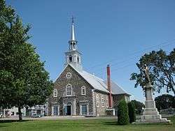
Saint-Pierre-les-Becquets is a municipality in the Centre-du-Québec region of the province of Quebec in Canada.
See also
References
External links

Adjacent Municipal Subdivisions | |
|---|---|
| Cities | |
|---|---|
| Municipalities | |
| Parishes | |
| |
This article is issued from
Wikipedia.
The text is licensed under Creative Commons - Attribution - Sharealike.
Additional terms may apply for the media files.