Saint Joseph, Portage County, Ohio
| St. Joseph, Ohio | |
|---|---|
| Unincorporated area | |
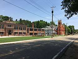 St. Joseph School, rectory, and church in 2018 | |
 St. Joseph, Ohio Location in Ohio and the United States  St. Joseph, Ohio St. Joseph, Ohio (the US) | |
| Coordinates: 41°01′38″N 81°17′57″W / 41.02722°N 81.29917°WCoordinates: 41°01′38″N 81°17′57″W / 41.02722°N 81.29917°W | |
| Country | United States |
| State | Ohio |
| County | Portage |
| Township | Randolph |
| Named for | St. Joseph Parish |
| Elevation | 1,161 ft (354 m) |
| Time zone | UTC−5 (EST) |
| • Summer (DST) | UTC−4 (EDT) |
| ZIP codes | 44260, 44201 |
| Area code(s) | 330, 234 |
| GNIS feature ID | 1049145[1] |
Saint Joseph is an unincorporated place in Portage County, Ohio, United States. It is located along Waterloo Road on the western edge of Randolph Township near its border with Suffield. The area is named after the Roman Catholic Parish of St. Joseph, established in 1831. In addition to the church building, which dates to 1904, the parish also includes a clergy house, elementary school for grades preschool through eighth, daycare center, cemetery, grotto, and food bank. A post office was located in the community from 1893 to 1904.[1][2][3]
References
- 1 2 "Feature Detail Report for: Saint Joseph". United States Geological Survey. July 12, 1979. Retrieved January 8, 2018.
- ↑ "Feature Detail Report for: Saint Joseph Post Office (historical)". United States Geological Survey. August 17, 1992. Retrieved January 8, 2018.
- ↑ "History of our Parish". St. Joseph Parish & School. 2018. Retrieved January 8, 2018.
Municipalities and communities of Portage County, Ohio, United States | ||
|---|---|---|
| Cities | 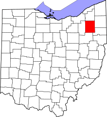 | |
| Villages | ||
| Townships | ||
| CDPs | ||
| Unincorporated communities | ||
| Historical places | ||
| Footnotes | ‡This populated place also has portions in an adjacent county or counties | |
This article is issued from
Wikipedia.
The text is licensed under Creative Commons - Attribution - Sharealike.
Additional terms may apply for the media files.