Ravenna Township, Portage County, Ohio
| Ravenna Township | |
|---|---|
| Civil township | |
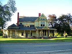 Farmhouse at the Crystal Lake Stock Farm | |
 Location within Portage County | |
| Coordinates: 41°10′7″N 81°14′43″W / 41.16861°N 81.24528°WCoordinates: 41°10′7″N 81°14′43″W / 41.16861°N 81.24528°W | |
| Country | United States |
| State | Ohio |
| County | Portage |
| Area | |
| • Total | 20.6 sq mi (53.4 km2) |
| • Land | 20.4 sq mi (52.8 km2) |
| • Water | 0.2 sq mi (0.6 km2) |
| Elevation[1] | 1,106 ft (337 m) |
| Population (2000) | |
| • Total | 9,270 |
| • Density | 454.5/sq mi (175.5/km2) |
| Time zone | UTC-5 (Eastern (EST)) |
| • Summer (DST) | UTC-4 (EDT) |
| ZIP code | 44266 |
| Area code(s) | 330, 234 |
| FIPS code | 39-65606[2] |
| GNIS feature ID | 1086837[1] |
Ravenna Township is one of the eighteen civil townships of Portage County, Ohio, United States. The 2000 census found 9,270 people in the township.[3]
Geography
Located in the center of the county, it borders the following townships and city:
- Shalersville Township - north
- Freedom Township - northeast corner
- Charlestown Township - east
- Edinburg Township - southeast corner
- Rootstown Township - south
- Brimfield Township - southwest corner
- Franklin Township - west
- Streetsboro - northwest corner
The city of Ravenna, the county seat of Portage County, which became independent of the township in 1993,[4] is surrounded by Ravenna Township.
Formed from Town 3, Range 8 of the Connecticut Western Reserve, Ravenna Township covers an area of 20 sq mi (52 km2).
Name and history
It is the only Ravenna Township statewide.[5] In the western part of the township along Ohio State Route 59 is the unincorporated town of Black Horse (or Blackhorse), named after the Blackhorse Tavern that was located there in the 19th century.[6]
Government
The township is governed by a three-member board of trustees, who are elected in November of odd-numbered years to a four-year term beginning on the following January 1. Two are elected in the year after the presidential election and one is elected in the year before it. There is also an elected township fiscal officer, who serves a four-year term beginning on April 1 of the year after the election, which is held in November of the year before the presidential election. Vacancies in the fiscal officership or on the board of trustees are filled by the remaining trustees.
References
- 1 2 "US Board on Geographic Names". United States Geological Survey. 2007-10-25. Retrieved 2008-01-31.
- ↑ "American FactFinder". United States Census Bureau. Retrieved 2008-01-31.
- ↑ Portage County, Ohio — Population by Places Estimates Ohio State University, 2007. Accessed 15 May 2007.
- ↑ "Census Bureau data". Archived from the original on 2011-06-29. Retrieved 2017-12-05.
- ↑ "Detailed map of Ohio" (PDF). United States Census Bureau. 2000. Retrieved 2007-02-16.
- ↑ Di Paolo, Roger (November 17, 2013). "Blackhorse Tavern was welcome sight for frontier travelers". Record-Courier. Retrieved June 6, 2016.
External links
Municipalities and communities of Portage County, Ohio, United States | ||
|---|---|---|
| Cities | 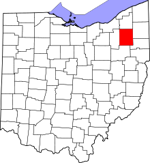 | |
| Villages | ||
| Townships | ||
| CDPs | ||
| Unincorporated communities | ||
| Historical places | ||
| Footnotes | ‡This populated place also has portions in an adjacent county or counties | |