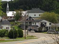
Saint-Côme, Quebec
- Not to be confused with Saint-Côme–Linière, Quebec, in the Chaudière-Appalaches region
| Saint-Côme | |
|---|---|
| Parish municipality | |
 | |
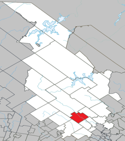 Location within Matawinie RCM | |
 Saint-Côme Location in central Quebec | |
| Coordinates: 46°16′N 73°47′W / 46.27°N 73.78°WCoordinates: 46°16′N 73°47′W / 46.27°N 73.78°W[1] | |
| Country |
|
| Province |
|
| Region | Lanaudière |
| RCM | Matawinie |
| Constituted | January 1, 1873 |
| Government[2] | |
| • Mayor | Martin Bordeleau (since 2013) |
| • Federal riding | Joliette |
| • Prov. riding | Berthier |
| Area[2][3] | |
| • Total | 169.30 km2 (65.37 sq mi) |
| • Land | 162.73 km2 (62.83 sq mi) |
| Population (2011)[3] | |
| • Total | 2,198 |
| • Density | 13.5/km2 (35/sq mi) |
| • Pop 2006-2011 |
|
| • Dwellings | 2,047 |
| Time zone | UTC−5 (EST) |
| • Summer (DST) | UTC−4 (EDT) |
| Postal code(s) | J0K 2B0 |
| Area code(s) | 450 and 579 |
| Highways |
|
| Website |
www |
Saint-Côme is a parish municipality in the Lanaudière region of Quebec, Canada, part of the Matawinie Regional County Municipality.
Demographics
Population
| Historical Census Data - Saint-Côme, Quebec[4] | ||
|---|---|---|
| Year | Pop. | ±% |
| 1991 | 1,710 | — |
| 1996 | 1,921 | +12.3% |
| 2001 | 1,923 | +0.1% |
| 2006 | 2,161 | +12.4% |
| 2011 | 2,198 | +1.7% |
Private dwellings occupied by usual residents: 1048 (total dwellings: 2047)
Language
Mother tongue:[5]
- English as first language: 0%
- French as first language: 98.6%
- English and French as first language: 0%
- Other as first language: 1.4%
Education
The Commission scolaire des Samares operates francophone public schools, including:
- École primaire de Saint-Côme[6]
The Sir Wilfrid Laurier School Board operates anglophone public schools, including:
- Joliette Elementary School in Saint-Charles-Borromée[7]
- Joliette High School in Joliette[8]
See also
References
- ↑ Reference number 55850 of the Commission de toponymie du Québec (in French)
- 1 2 Geographic code 62065 in the official Répertoire des municipalités (in French)
- 1 2 "(Code 2462065) Census Profile". 2011 census. Statistics Canada. 2012.
- ↑ Statistics Canada: 1996, 2001, 2006, 2011 census
- ↑ Statistics Canada 2006 Census - Saint-Côme community profile
- ↑ "de Saint-Côme." Commission scolaire des Samares. Retrieved on September 20, 2017.
- ↑ "JOLIETTE ELEMENTARY ZONE." Sir Wilfrid Laurier School Board. Retrieved on September 17, 2017.
- ↑ "Joliette High School Zone Sec 1-5." Sir Wilfrid Laurier School Board. Retrieved on September 5, 2017.
External links

Adjacent Municipal Subdivisions | |
|---|---|
| Municipalities | |
|---|---|
| Parishes | |
| Unorganized Territories | |
| |
This article is issued from
Wikipedia.
The text is licensed under Creative Commons - Attribution - Sharealike.
Additional terms may apply for the media files.