Saint-Damien, Quebec
| Saint-Damien | |||
|---|---|---|---|
| Parish municipality | |||
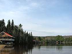 Lake Gauthier | |||
| |||
| Motto(s): Per fidem ad Augusta | |||
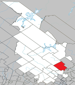 Location within Matawinie RCM | |||
 St-Damien Location in central Quebec | |||
| Coordinates: 46°20′N 73°29′W / 46.33°N 73.48°WCoordinates: 46°20′N 73°29′W / 46.33°N 73.48°W[1] | |||
| Country |
| ||
| Province |
| ||
| Region | Lanaudière | ||
| RCM | Matawinie | ||
| Constituted | September 6, 1870 | ||
| Government[2] | |||
| • Mayor | Yves Giard | ||
| • Federal riding | Joliette | ||
| • Prov. riding | Berthier | ||
| Area[2][3] | |||
| • Total | 268.50 km2 (103.67 sq mi) | ||
| • Land | 255.16 km2 (98.52 sq mi) | ||
| Population (2011)[3] | |||
| • Total | 2,020 | ||
| • Density | 7.9/km2 (20/sq mi) | ||
| • Pop 2006-2011 |
| ||
| • Dwellings | 1,533 | ||
| Time zone | UTC−5 (EST) | ||
| • Summer (DST) | UTC−4 (EDT) | ||
| Postal code(s) | J0K 2E0 | ||
| Area code(s) | 888 | ||
| Highways |
| ||
| Website |
www | ||


Saint-Damien (formerly named Saint-Damien-de-Brandon) is a parish municipality of 2,020 inhabitants in Quebec, Canada. It is located in Matawinie Regional County Municipality in the Lanaudière region.
History
The town was founded the 6 September 1870. In French, people from the town are known as damiennois.[2]
Geography
Saint-Damien is located in the middle of Lanaudière region near Saint-Gabriel-de-Brandon municipality, about 100 kilometres (62 mi) north of Montreal, 270 kilometres (170 mi) west of Québec, and 63 kilometres (39 mi) south of Taureau Reservoir. The main street is named "Rue Principale" (meaning, literally, "main street")[4] and it is served by Quebec Route 347 which runs from Quebec Route 158 at Sainte-Geneviève-de-Berthier (2 km west of exit 144 on Autoroute 40) through Saint-Gabriel-de-Brandon, Saint Damien, Sainte-Émélie-de-l'Énergie and Saint-Côme to Québec Route 125 in Notre-Dame-de-la-Merci.
The bordering municipalities [5] of Saint-Damien [6] are, starting from northwest and proceeding clockwise, Saint-Zénon (northwest), Mandeville (northeast, in D'Autray Regional County Municipality), Saint-Gabriel-de-Brandon (southeast, in D'Autray Regional County Municipality), Saint-Jean-de-Matha (south) and Sainte-Émélie-de-l'Énergie (west).
Demographics
Population
| Historical Census Data - Saint-Damien, Quebec[7] | ||||||||||||||||||||||||||||
|---|---|---|---|---|---|---|---|---|---|---|---|---|---|---|---|---|---|---|---|---|---|---|---|---|---|---|---|---|
|
| |||||||||||||||||||||||||||
(A) adjusted figures due to boundary changes. | ||||||||||||||||||||||||||||
Private dwellings occupied by usual residents: 979 (total dwellings: 1533)
Language
Mother tongue:[8]
- English as first language: 0.9%
- French as first language: 95.4%
- English and French as first language: 0.5%
- Other as first language: 3.2%
Education
The Commission scolaire des Samares operates francophone public schools, including:
- École Saint-Coeur-de-Marie[9]
The Sir Wilfrid Laurier School Board operates anglophone public schools, including:
- Joliette Elementary School in Saint-Charles-Borromée[10]
- Joliette High School in Joliette[11]
Famous people
- Marie Jean-Eudes (1897-1981), Canadian nun and botanist
- Raymond Gravel (b. 1952), Canadian politician
See also
References
- ↑ Reference number 55883 of the Commission de toponymie du Québec (in French)
- 1 2 3 Geographic code 62075 in the official Répertoire des municipalités (in French)
- 1 2 Statistics Canada 2011 Census - Saint-Damien census profile
- ↑ Main Street
- ↑ (in French) Municipal affairs and regions – regional maps Archived 2008-05-02 at the Wayback Machine.
- ↑ (in French) Repertory of municipalities of Archived 2009-01-09 at the Wayback Machine.
- ↑ Statistics Canada: 1996, 2001, 2006, 2011 census
- ↑ Statistics Canada 2006 Census - Saint-Damien community profile
- ↑ "Saint-Coeur-de-Marie." Commission scolaire des Samares. Retrieved on September 23, 2017.
- ↑ "JOLIETTE ELEMENTARY ZONE." Sir Wilfrid Laurier School Board. Retrieved on September 17, 2017.
- ↑ "Joliette High School Zone Sec 1-5." Sir Wilfrid Laurier School Board. Retrieved on September 5, 2017.
External links
| Wikimedia Commons has media related to Saint-Damien, Quebec. |
- (in French) Saint-Damien official website
- (in English) Town flag and informations at FOTW
Adjacent Municipal Subdivisions | |
|---|---|
| Municipalities | |
|---|---|
| Parishes | |
| Unorganized Territories | |
| |