Route 9 (Uruguay)
| ||||
|---|---|---|---|---|
| Ruta 9 | ||||
| Coronel Leonardo Olivera | ||||
 | ||||
| Route information | ||||
| Maintenance: Ministry of Transport & Public Works | ||||
| Length | 274 km (170 mi) | |||
| Major junctions | ||||
| West end | near Dr. Francisco Soca | |||
| East end | Chuy | |||
| Highway system | ||||
| ||||

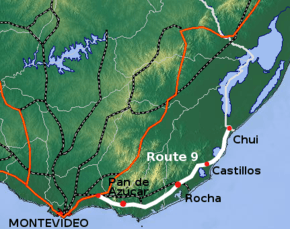
Route 9 is a national route of Uruguay. In 1975, it was assigned the name Coronel Leonardo Olivera, a national hero of Uruguay.[1] It connects Dr. Francisco Soca with Chuy in the northeast.[2]
The distance notation along Route 9 uses the same Kilometre Zero reference as Routes 1, 3, 5, 6, 7, 8, 10 and IB, which is the Pillar of Peace of Plaza de Cagancha in the Centro of Montevideo.[3] The length of the road, from its beginning at Km. 66 to its end at Km. 340 is 274 kilometres (170 mi) in length.
Destinations and junctions
These are the populated places Route 9 passes through, as well as its main junctions with other National Roads.
- Km. 66 of Route 8 near Dr. Francisco Soca.
- Km. 78 Route 70 South to Cuchilla Alta.
- Km. 89 Gregorio Aznárez
- Km. 94 Merges Ruta Interbalnearia near Solís.
- Km. 104/105 Splits from Ruta Interbalnearia, Route 37 South to Piriápolis.
- Km. 106 Pan De Azúcar, Route 60 North to Minas.
- Km. 126 Route 12 Northwest to Minas, South to Punta Ballena.
- Km. 137 Route 39 North to Aiguá, South to San Carlos, Maldonado & Punta del Este.
- Km. 144 Route 104 Southeast to Manatiales.
- Km. 161 Camino Sainz Martinez South to Faro José Ignacio.
- Km. 208/210 Rocha, Route 109 Northwest to Aiguá & Route 15 Southeast to La Paloma.
- Km. 236 19 de Abril
- Km. 265 Castillos, Route 16 North to Route 14, Southeast to Aguas Dulces.
- Km. 281 La Esmeralda
- Km. 299 Road Southeast to Punta del Diablo.
- Km. 302/304 Santa Teresa (Parque Nacional & Fortaleza)
- Km. 312 Route 14 West & Northwest to Lascano and José Pedro Varela.
- Km. 315 La Coronilla
- Km. 340 Chuy, Route 19 East to Fuerte San Miguel, 18 de Julio and to Route 15. Also connects with Federal Route BR-471 of Brazil.
References
- ↑ "LEY N° 14.361". República Oriental del Uruguay, Poder Legislativo. 1975. Archived from the original on 7 March 2014. Retrieved 19 July 2011.
- ↑ "Mapas & Planos - República Oriental del Uruguay". Reservas.net. Retrieved 2 June 2011.
- ↑ "Kilómetro cero en Plaza Cagancha". Junta Departamental de Montevideo. 25 March 2010. Archived from the original on 29 June 2012. Retrieved 21 July 2011.
External links
This article is issued from
Wikipedia.
The text is licensed under Creative Commons - Attribution - Sharealike.
Additional terms may apply for the media files.