Route 3 (Uruguay)
| ||||
|---|---|---|---|---|
| Ruta 3 | ||||
| General José Artigas | ||||
 | ||||
 | ||||
| Route information | ||||
| Maintenance: Ministry of Transport & Public Works | ||||
| Length | 564.6 km (350.8 mi) | |||
| Major junctions | ||||
| South end |
Km.67 of Route 1 (near Puntas de Valdez & Rafael Perazza) Kilometre Zero is in Centro, Montevideo | |||
|
San José Department: | ||||
| North end | Bella Unión | |||
| Highway system | ||||
| ||||

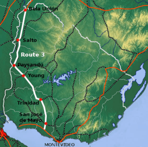
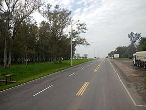
Route 3 is a national route of Uruguay. In 1975, it was assigned the name General José Artigas, the foremost national hero of Uruguay.[1] It is one of the most important highways in the country along with Route 5, connecting the south coast near Rafael Perazza with Bella Unión in the extreme northwest. The road is approximately 592 kilometres (368 mi) in length.[2][3]
Although Route 3 starts at Km. 67 of Route 1, its distance notation uses the same Kilometre Zero reference as Routes 1, 5, 6, 7, 8, 9 and IB, which is the Pillar of Peace of Plaza de Cagancha in the Centro of Montevideo.[4]
Destinations and junctions
These are the populated places Route 3 passes through, as well as its main junctions with other National Roads.
- San José Department
- Km. 67 of Route 1, between Puntas de Valdez & Rafael Perazza.
- Km. 90 San José de Mayo, Route 11 West to Ecilda Paullier and East to Atlántida.
- Km. 189 Trinidad, Route 14 West to Mercedes and East to Durazno and La Coronilla at the coast of Rocha.
- Km. 238 crosses Río Negro and enters Río Negro Department.
- Km. 317 Young Route 25 South to Route 24 and North to Route 90.
- Km. 376 Paysandú, Route 90 East.
- Km. 381 a 6 km road connects it with International Bridge General Artigas into Route 135 of Argentina.
- Km. 410 Route 26 East-Southeast to Tacuarembó and Melo.
- Km. 441 Termas de Guaviyú
- Salto Department
- Km. 488 Termas del Daymán
- Km. 496 Salto, Route 31 Southeast to Tacuarembó.
- Artigas Department
- Km. 636 Route 30 Northeast to Artigas.
- Km. 659 Bella Unión - connects to Brazilian Federal Road BR-472.
References
- ↑ "LEY N° 14.361". República Oriental del Uruguay, Poder Legislativo. 1975. Archived from the original on 7 March 2014. Retrieved 19 July 2011.
- ↑ "Mapas & Planos - República Oriental del Uruguay". Reservas.net. Retrieved 2 June 2011. (Note: Length=180km, evidently a mistake)
- ↑ "Information about the routes of Uruguay" (in Spanish). Turismo en Uruguay – Turismo Uruguayo .com. 2011. Retrieved 16 July 2011.
- ↑ "Kilómetro cero en Plaza Cagancha". Junta Departamental de Montevideo. 25 March 2010. Archived from the original on 29 June 2012. Retrieved 21 July 2011.
External links
Route map:
Coordinates: 32°41′30″S 57°38′34.4″W / 32.69167°S 57.642889°W