Minas, Uruguay
| Minas | |
|---|---|
| Capital city | |
 | |
 Minas | |
| Coordinates: 34°22′0″S 55°14′0″W / 34.36667°S 55.23333°WCoordinates: 34°22′0″S 55°14′0″W / 34.36667°S 55.23333°W | |
| Country |
|
| Department |
|
| Founded | 1783 |
| Area | |
| • Total | 8.2 km2 (3.2 sq mi) |
| Elevation | 140 m (460 ft) |
| Population (2011 Census) | |
| • Total | 38,446 |
| • Density | 4,745/km2 (12,290/sq mi) |
| • Demonym | minuano |
| Time zone | UTC -3 |
| Postal code | 30000 |
| Dial plan | +598 444 (+5 digits) |
| Climate | Cfa |
| Website | lavalleja.gub.uy |
Minas (Spanish pronunciation: [ˈminas]) is the capital of the Lavalleja Department in Uruguay. As of the census of 2011, it is the twelfth-most populated city in the country.
Location
The city is located in the south of the department, on the intersection of Route 8 with Route 12.
Geography
It lies between hill ranges and the basins of the Arroyo San Francisco and Arroyo Campanero streams.
History
A town was founded here in 1783 as "Villa de la Concepción de las Minas" when a number of families from the Asturias and Galicia regions of Spain settled in the area following a frustrated attempt to populate Patagonia. The idea of a city in the area was first raised in 1753 by Jose Joaquin de Viana, the governor of Montevideo, who wanted to create a population centre in "the zones of the mines". He commissioned Rafael Perez Del Puerto to design the layout of the city, the basis of which remains in place today.
On October 8th, 1830, it was declared a town, and on June 16th, 1837, by decree Ley Nº 158, it became the capital of the "Department of Minas". On May 16th, 1888, its status was elevated city) by decree Ley Nº 1.980. On December 26th, 1927, after the renaming of the department, it became the capital of the "Department of Lavalleja" by decree Ley Nº 8.187.[1]
Population
According to the 2011 census, the area of Minas had a population of 38,446.[2][3]
The following areas are considered by some as part of the Minas urban area:
- Blanes Viale: 104
- Barrio La Coronilla - Ancap: 301
- San Francisco de las Sierras: 58
As a result, the total population of the Minas area can be said to be 38,909.
| Year | Population |
|---|---|
| 1908 | 13,345 |
| 1963 | 31,256 |
| 1975 | 35,225 |
| 1985 | 34,658 |
| 1996 | 37,146 |
| 2004 | 37,925 |
| 2011 | 38,446 |
Source: Instituto Nacional de Estadística de Uruguay[1]
Features
- In the city
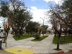
In the northeastern part of the city, there is the big Parque Rodó, which contains a zoological garden, a public open air swimming pool, an area for picnics, and a small soccer field.
Cerro Artigas
At the east end of the city is Cerro Artigas, a hill with a park containing a statue of the 19th-century Uruguayan hero General José Artigas on horseback.
- Surrounding area
The Parque Salto del Penitente lies 16 kilometres (9.9 mi) east of the city; 9 kilometres (5.6 mi) to the west-southwest is Parque Salus and 6 kilometres (3.7 mi) to the southeast is the Parque de Vacaciones UTE-ANTEL, a park for the vacation use of employees of the Uruguayan Electricity Company and the Uruguayan Telecommunications Company. Villa Serrana is a scenic village located in the hills about 25 kilometres (16 mi) northeast of Minas.
Places of worship
- Cathedral of the Immaculate Conception (Roman Catholic)
- St. Joseph Parish Church (Roman Catholic)
- St. Thérèse of Lisieux Parish Church (Roman Catholic, Redemptorists)
- Our Lady of Fatima Parish Church (Roman Catholic)
- Our Lady of Verdun National Sanctuary, a popular pilgrimage shrine on top of Verdún Hill[4]
Famous people
Minas is the birthplace of:
- Juan Antonio Lavalleja, the revolutionary leader during Uruguayan independence, after whom the department is named.
- Juan José Morosoli, Uruguayan writer.
- Eduardo Gavarret, Seventy of The Church of Jesus Christ of Latter-day Saints, first person to deliver a live general conference address in Spanish.
- Sebastián Abreu, Uruguaya professional soccer player.
Twin towns
References
- 1 2 "Statistics of urban localities (1908–2004)". INE. 2012. Archived from the original (PDF) on 23 March 2015. Retrieved 4 September 2012.
- ↑ "Censos 2011 Cuadros Lavalleja". INE. 2012. Archived from the original on 10 October 2012. Retrieved 25 August 2012.
- ↑ "Censos 2011 Lavalleja". INE. 2012. Archived from the original on 5 November 2012. Retrieved 25 August 2012.
- ↑ Verdun Sanctuary (in Spanish)
External links
Capital: Minas | ||
| Towns and villages | 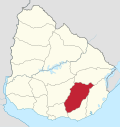 | |
| Sights | ||