Aiguá
| Aiguá | |
|---|---|
| City & Municipality | |
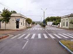 Avenida Artigas, an avenue in Aiguá. | |
 Aiguá | |
| Coordinates: 34°12′0″S 54°45′0″W / 34.20000°S 54.75000°WCoordinates: 34°12′0″S 54°45′0″W / 34.20000°S 54.75000°W | |
| Country | Uruguay |
| Department |
|
| Founded | 1892 |
| Founded by | Margarita Muniz |
| Elevation | 112 m (367 ft) |
| Population (2011 Census) | |
| • Total | 2,465 |
| Time zone | UTC -3 |
| Postal code | 20500 |
| Dial plan | +598 4446 (+4 digits) |
| Climate | Cfa |
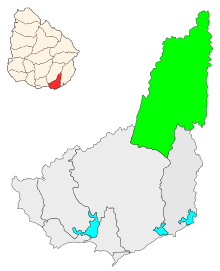
Aiguá (Spanish pronunciation: [aiˈɣwa]) is a city of the Maldonado Department in Uruguay. Its name means running water in the Guaraní language. It is also the name of the municipality to which the city belongs. It includes the following zones: Aiguá, Sauce de Aiguá, Sarandí de Aiguá, Alférez, Valdivia, Salamanca, Coronilla, Rincón de Aparicio, Los Talas, Paso de los Talas.
Location
The city is located at the north of the department, at the intersection of Route 39 with Route 109, 88 kilometres (55 mi) north of the capital city, Maldonado.
Geography
The city is situated on the east bank of the stream Arroyo de Aiguá, one of the main tributaries of Cebollatí River.
The municipality of Aiguá has the highest point of Uruguay, the Cerro Catedral. This point is situated at an altitude of 513.66 metres (1,685.2 ft).
History
On 9 May 1906 it was declared a "Pueblo" (village)[1] and its status was elevated to "Ciudad" (city) on 4 January 1956 by decree Ley No. 12.265.[2]
Population
In 2011 Aiguá had a population of 2,465.[3] According to the Intendencia Departamental de Maldonado, the municipality of Aiguá has a population of 4,500.[4]
| Year | Population |
|---|---|
| 1908 | 4,763 |
| 1963 | 2,715 |
| 1975 | 2,470 |
| 1985 | 2,362 |
| 1996 | 2,567 |
| 2004 | 2,676 |
| 2011 | 2,465 |
Source: Instituto Nacional de Estadística de Uruguay[1]
Places of worship
- Parish Church of St. Anthony of Padua and Our Lady of the Valley of Aiguá (Roman Catholic)
Notable people
- Domingo Burgueño Miguel, mayor of Maldonado
- Arturo Fajardo, Roman Catholic bishop
See also
References
- 1 2 "Statistics of urban localities (1963–2004)". INE. 2012. Archived from the original (PDF) on 23 March 2015. Retrieved 6 September 2012.
- ↑ "LEY N° 12.265". República Oriental del Uruguay, Poder Legislativo. 1956. Archived from the original on 4 March 2016. Retrieved 6 September 2012.
- ↑ "Censos 2011 Cuadros Maldonado". INE. 2012. Archived from the original on 10 October 2012. Retrieved 25 August 2012.
- ↑ "Presupuesto-2011-2015". Intendencia Departamnetal de Maldonado. 2012. Archived from the original on 24 April 2011. Retrieved 11 September 2012.
External links
| Wikimedia Commons has media related to Aiguá. |
- (in Spanish) Ciudad de Aiguá, Site of the municipality of Maldonado, Uruguay.
- INE map of Aiguá
Capital: | ||
| Towns and villages | 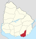 | |
| Sights | ||