Melo, Uruguay
| Melo | |
|---|---|
| Capital city | |
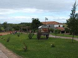 The Posta del Chuy, near Melo | |
 Melo | |
| Coordinates: 32°22′0″S 54°11′0″W / 32.36667°S 54.18333°WCoordinates: 32°22′0″S 54°11′0″W / 32.36667°S 54.18333°W | |
| Country |
|
| Department |
|
| Founded | 1795 |
| Founded by | Agustín de la Rosa |
| Elevation | 80 m (260 ft) |
| Population (2011 Census) | |
| • Total | 51,830 |
| • Demonym | melense |
| Time zone | UTC -3 |
| Postal code | 37000 |
| Dial plan | +598 64 (+6 digits) |
| Climate | Cfa |
| Website | Official site of Cerro Largo |
Melo (Spanish pronunciation: [ˈmelo]) is the capital city of the Cerro Largo Department of north-eastern Uruguay. As of the census of 2011, it is the ninth most populated city of the country.
Location
It is located at the center of the department, on the intersection of Route 7 with Route 8, 60 kilometres (37 mi) south of Aceguá and the border with Brazil. Other primary roads to the city are Route 26 and Route 44.
Geography
The stream Arroyo Conventos (a tributary of Tacuarí River) flows by the west limits of the city.
History
It was founded on 27 June 1795 by Agustín de la Rosa, an officer to the Spanish Empire.[1] It was named after Pedro Melo de Portugal, a Spanish colonial official of Portuguese royal ancestry.
Given its proximity to some Portuguese colonies in Brazil, the "Melo Village" (in Spanish, "Villa de Melo"), as it was once named, was invaded by Portuguese forces in 1801, 1811, and 1816. With Uruguayan independence, Melo was officially declared capital of the department of Cerro Largo.
In 1845, the city square was renamed in honor of Manuel Oribe, a former President of Uruguay and a political leader of the White Party (Partido Blanco), which brought to light the relations of this corner of the country with that National Movement (the vast majority of its inhabitants have belonged to that same political community).
Melo had acquired the status of "Villa" (town) before the Independence of Uruguay. Its status was elevated to "Ciudad" (city) on 22 May 1895 by the Act of Ley Nº 2.3279.[2] It was capital of one of the nine original departments of the Republic.
The historian J.C. Chasteen has discussed the place of Melo in the history of Uruguay in his book Heroes on Horseback: A Life and Times of the Last Gaucho Caudillos.[3]
Population

In 2011 Melo had a population of 51,830 inhabitants.[4]
| Year | Population |
|---|---|
| 1908 | 12,355 |
| 1963 | 33,741 |
| 1975 | 38,487 |
| 1985 | 42,245 |
| 1996 | 46,883 |
| 2004 | 50,578 |
| 2011 | 51,830 |
Source: Instituto Nacional de Estadística de Uruguay[5]
Climate
Melo has a humid subtropical climate, described by the Köppen climate classification as Cfa. Summers are warm (with hot days and cool nights) and winters are cool, with frequent frosts and fog. The precipitation is evenly distributed throughout the year, with an average of 1,241 mm (48.85 in), and the annual average temperature is 17 °C (63 °F).
This city has the lowest recorded temperature in Uruguay, of -11 °C (12.2 °F), on June 14, 1967.[6]
| Climate data for Melo, Cerro Largo | |||||||||||||
|---|---|---|---|---|---|---|---|---|---|---|---|---|---|
| Month | Jan | Feb | Mar | Apr | May | Jun | Jul | Aug | Sep | Oct | Nov | Dec | Year |
| Record high °C (°F) | 43.0 (109.4) |
40.5 (104.9) |
40.4 (104.7) |
38.0 (100.4) |
32.3 (90.1) |
30.2 (86.4) |
30.0 (86) |
32.0 (89.6) |
37.0 (98.6) |
37.0 (98.6) |
38.4 (101.1) |
45.0 (113) |
45.0 (113) |
| Average high °C (°F) | 30.5 (86.9) |
29.7 (85.5) |
27.3 (81.1) |
23.6 (74.5) |
19.9 (67.8) |
17.2 (63) |
17.1 (62.8) |
18.3 (64.9) |
20.0 (68) |
23.0 (73.4) |
25.9 (78.6) |
28.4 (83.1) |
23.4 (74.1) |
| Daily mean °C (°F) | 23.2 (73.8) |
22.8 (73) |
20.8 (69.4) |
17.2 (63) |
13.9 (57) |
11.1 (52) |
11.5 (52.7) |
12.4 (54.3) |
14.1 (57.4) |
16.9 (62.4) |
18.9 (66) |
21.7 (71.1) |
17.0 (62.6) |
| Average low °C (°F) | 17.0 (62.6) |
16.0 (60.8) |
15.0 (59) |
12.3 (54.1) |
8.0 (46.4) |
5.1 (41.2) |
7.0 (44.6) |
7.7 (45.9) |
9.6 (49.3) |
12.0 (53.6) |
14.6 (58.3) |
14.7 (58.5) |
11.8 (53.2) |
| Record low °C (°F) | 1.0 (33.8) |
3.6 (38.5) |
0.0 (32) |
−5.2 (22.6) |
−5.9 (21.4) |
−11.0 (12.2) |
−9.6 (14.7) |
−4.8 (23.4) |
−4.0 (24.8) |
−3.0 (26.6) |
1.2 (34.2) |
4.0 (39.2) |
−11.0 (12.2) |
| Average precipitation mm (inches) | 105 (4.13) |
114 (4.49) |
96 (3.78) |
79 (3.11) |
99 (3.9) |
95 (3.74) |
129 (5.08) |
112 (4.41) |
121 (4.76) |
102 (4.02) |
102 (4.02) |
83 (3.27) |
1,238 (48.74) |
| Average precipitation days (≥ 1.0 mm) | 5 | 6 | 5 | 5 | 5 | 6 | 6 | 5 | 6 | 6 | 5 | 4 | 65 |
| Average relative humidity (%) | 64 | 68 | 72 | 74 | 76 | 86 | 83 | 80 | 78 | 71 | 75 | 67 | 74 |
| Mean monthly sunshine hours | 264.1 | 206.0 | 236.6 | 192.1 | 175.9 | 140.3 | 152.2 | 165.5 | 172.1 | 232.1 | 235.8 | 288.7 | 2,461.4 |
| Source: Dirección Nacional de Meteorología (extremes 1937–1994)[7][8] | |||||||||||||
Features
There are two museums:
- Juana de Ibarbourou's birthplace
- Regional History Museum
Near Melo is situated the old Posta del Chuy, a stone inn near an ancient bridge over the Chuy del Tacuarí creek.
Melo was visited by Pope John Paul II in 1988. This formed the background to the 2006 film El Baño del Papa (The Pope's Toilet) about an enterprising citizen with the ill-fated idea of making money by building a toilet and charging the hordes of Brazilians expected to visit Melo to see the Pope.
Places of worship
- Cathedral of Our Lady of the Pillar and St. Raphael (Roman Catholic)
- Parish Church of Our Lady of Mt. Carmel (Roman Catholic)
- Parish Church of St. Joseph the Worker (Roman Catholic)
- Parish Church of St. Dominic Savio and St. Charles Borromeo (Roman Catholic, Salesians of Don Bosco)
- Jesus Good Shepherd Parish Church (Roman Catholic, Sisters of Santa Dorotea di Cemmo)
See also
Bibliography
- Domínguez, Carlos María (2004). El norte profundo (in Spanish). Montevideo: Ediciones de la Banda Oriental.
References
- ↑ History of Melo - from the book of Camilo Urueña González -Crónicas de Cerro Largo 1945 - Official website of Cerro Largo Archived 2011-10-05 at the Wayback Machine.
- ↑ "LEY N° 9.888". República Oriental del Uruguay, Poder Legislativo. 1995. Archived from the original on 26 October 2014. Retrieved 4 July 2011.
- ↑ John Charles Chasteen, Heroes on Horseback: A Life and Times of the Last Gaucho Caudillos, University of New Mexico Press. ISBN 0-8263-1598-4.
- ↑ "Censos 2011 Cuadros Cerro Largo". INE. 2012. Archived from the original on 10 October 2012. Retrieved 25 August 2012.
- ↑ "Statistics of urban localities (1908–2004)". INE. 2012. Archived from the original (PDF) on 23 March 2015. Retrieved 3 September 2012.
- ↑ (in Spanish) Récords meteorológicos del Uruguay, Dirección Nacional de Meteorología. Retrieved 31 December 2010.
- ↑ "Estadísticas climatológicas" (in Spanish). Dirección Nacional de Meteorología. Retrieved 28 September 2016.
- ↑ "RECORDS METEOROLOGICOS EN EL URUGUAY" (in Spanish). Dirección Nacional de Meteorología. Retrieved 28 September 2016.
External links
Capital: Melo | ||
| Towns and villages | 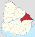 | |
| Sights | ||