Rottweil (district)
| Rottweil | |
|---|---|
| District | |
 | |
| Country |
|
| State | Baden-Württemberg |
| Adm. region | Freiburg |
| Capital | Rottweil |
| Area | |
| • Total | 769.48 km2 (297.10 sq mi) |
| Population (31 December 2017)[1] | |
| • Total | 138,858 |
| • Density | 180/km2 (470/sq mi) |
| Time zone | UTC+01:00 (CET) |
| • Summer (DST) | UTC+02:00 (CEST) |
| Vehicle registration | RW |
| Website | http://www.landkreis-rottweil.de |
Rottweil is a Landkreis (district) in the middle of Baden-Württemberg, Germany. It is part of the Schwarzwald-Baar-Heuberg region in the Breisgau-Hochschwarzwald regional district. Neighboring districts are (from north clockwise) Freudenstadt, Zollernalbkreis, Tuttlingen, Schwarzwald-Baar and Ortenaukreis.
History
The district dates back to the Oberamt Rottweil, which was created in 1806/08 when the previously free imperial city Rottweil became part of Württemberg. In 1934 it was renamed to Landkreis (district). 1938 the two neighboring districts Sulz and Oberndorf were dissolved, and most of the district Oberndorf and a small part of Sulz was added to the district Rottweil. During World War II, a series of Nazi concentration camps, collectively known as KZ Schörzingen-Rottweil-Zepfenhan, were located in the area.[2] In 1973 in another communal reform several municipalities from the districts Horb, Wolfach, Hechingen and Villingendorf were added.
Geography
The district covers part of the mountains of the Black Forest and the Swabian Alb. The Neckar River bisects the district from south to north as it flows towards the Rhine River.
Coat of arms
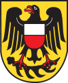 |
The imperial eagle in the coat of arms derives from the coat of arms of the free imperial city Rottweil. Below the eagle is a deer antler, the symbol of Württemberg, as part of the district belonged to the kingdom Württemberg well before Rottweil itself became part of it. The shield on the breast of the eagle show the colors of Austria, symbolizing the area around the city of Oberndorf which was acquired by Austria in 1381. |
Cities and towns

| Cities | Administrative districts | Towns | |
|---|---|---|---|
|
References
- ↑ "Bevölkerung nach Nationalität und Geschlecht am 31. Dezember 2017". Statistisches Landesamt Baden-Württemberg (in German). 2018.
- ↑ Christine O'Keefe.Concentration Camps.www.tartanplace.com/tartanhistory/concentrationcamps.html
External links
| Wikimedia Commons has media related to Landkreis Rottweil. |
Towns and municipalities in Rottweil (district) | ||
|---|---|---|