Sulz am Neckar
| Sulz am Neckar | ||
|---|---|---|
| ||
 Sulz am Neckar Location of Sulz am Neckar within Rottweil district 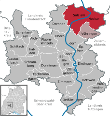  | ||
| Coordinates: 48°21′46″N 8°37′54″E / 48.36278°N 8.63167°ECoordinates: 48°21′46″N 8°37′54″E / 48.36278°N 8.63167°E | ||
| Country | Germany | |
| State | Baden-Württemberg | |
| Admin. region | Freiburg | |
| District | Rottweil | |
| Government | ||
| • Mayor | Gerd Hieber | |
| Area | ||
| • Total | 87.60 km2 (33.82 sq mi) | |
| Elevation | 443 m (1,453 ft) | |
| Population (2017-12-31)[1] | ||
| • Total | 12,267 | |
| • Density | 140/km2 (360/sq mi) | |
| Time zone | CET/CEST (UTC+1/+2) | |
| Postal codes | 72168–72172 | |
| Dialling codes | 07454 | |
| Vehicle registration | RW | |
| Website | www.sulz.de | |

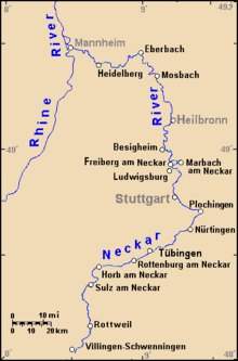
Sulz am Neckar is a town in the district of Rottweil, in Baden-Württemberg, Germany. It is situated on the river Neckar, 22 km north of Rottweil, and 19 km southeast of Freudenstadt.
Sulz am Neckar came in the possession of the Hohengeroldseck in AD 1242.
At Sulz a powerline for traction current crosses the Neckar Valley in a large span, which is mounted on two 61-metre-tall electricity pylons.
People from Sulz am Neckar

- Friedrich August von Alberti (1795-1878), geologist
- Gustav Bauernfeind (1848–1904), painter
- Joseph Gottlieb Kölreuter (1733-1806), botanist, professor of natural history
- Brigitte Peterhans (b.1928-), architect
- Richard Schmid (1899–1986), lawyer and politician (SPD Landesminister in Baden-Württemberg) and member of the German resistance).
- Salomon Schweigger (1551–1622 ), Lutheran theologian, anthropologist, orientalist and pilgrim
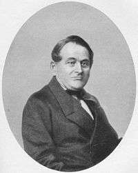
- Carl Reinhold August Wunderlich (1815–77), physician and pioneer psychiatrist.
Gallery
 Römerkeller
 Free Baptist Church Sulz am Neckar
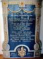 Epitaph on Magnus Friedrich Roos
 Water castle and rectory in Glatt
Sulz am Neckar
Sulz am Neckar on Neckar River
References
- ↑ "Bevölkerung nach Nationalität und Geschlecht am 31. Dezember 2017". Statistisches Landesamt Baden-Württemberg (in German). 2018.
| Wikimedia Commons has media related to Sulz am Neckar. |
Towns and municipalities in Rottweil (district) | ||
|---|---|---|
This article is issued from
Wikipedia.
The text is licensed under Creative Commons - Attribution - Sharealike.
Additional terms may apply for the media files.