Dietingen
| Dietingen | ||
|---|---|---|
| ||
 Dietingen Location of Dietingen within Rottweil district 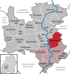  | ||
| Coordinates: 48°12′20″N 08°38′46″E / 48.20556°N 8.64611°ECoordinates: 48°12′20″N 08°38′46″E / 48.20556°N 8.64611°E | ||
| Country | Germany | |
| State | Baden-Württemberg | |
| Admin. region | Freiburg | |
| District | Rottweil | |
| Government | ||
| • Mayor | Frank Scholz | |
| Area | ||
| • Total | 42.25 km2 (16.31 sq mi) | |
| Elevation | 575 m (1,886 ft) | |
| Population (2017-12-31)[1] | ||
| • Total | 4,011 | |
| • Density | 95/km2 (250/sq mi) | |
| Time zone | CET/CEST (UTC+1/+2) | |
| Postal codes | 78661 | |
| Dialling codes | 0741 bzw. 07404 | |
| Vehicle registration | RW | |
| Website | www.dietingen.de | |
Dietingen is a municipality in the district of Rottweil, in Baden-Württemberg, Germany.
Geography
Dietingen is located in the Upper Neckar valley between the Black Forest and the Swabian Jura in 544–623 meters altitude, about five kilometers away from the town of Rottweil.
Neighboring communities
The municipality borders to Epfendorf, on the east to Rosenfeld and Zimmern unter der Burg in the Zollernalbkreis, in the south to the county town Rottweil and in the west to Villingendorf.
Municipality arrangement
The municipality Dietingen includes the formerly independent municipalities Böhringen, Gößlingen, Irslingen and Rotenzimmern.
- To Böhringen belonged the village Böhringen and residential spaces Böhringer mill and chapel courtyard.
- To Dietingen belonged before the local government reform in the 1970s the village Dietingen, the castle and farmstead Hohenstein, the farm Tierstein and the living space Hasler-Wasen.
- To Gößlingen belonged the village Gößlingen.
- To Irslingen belonged the village Irslingen, Häuser, chapel Maria Hochheim.
- To Rotenzimmern belonged the village Rotenzimmern and the Bettenberger Hof.
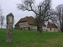
In the hamlet of Irslingen is situated Burgstall Tierstein respectively castle Wildeck.[2]
Crests of the former municipalities
.png) Crest of Boehringen
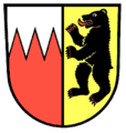
Crest of Boehringen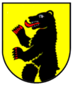 Old crest of Dietingen
 Crest of Goesslingen
 Crest of Irslingen
Tourism
Tourist trains on weekends in the summer
About Schömberg and Balingen the station Rotenzimmern can be reached over a wheel hiking shuttle from Tübingen. (free bicycle transport on weekends and holidays in the summer).[3] The Hohenzollerische Landesbahn reaches with coupled railcars from Tübingen to Kleinengstingen the Upper Danube Nature Park and continues by bus till the starting point of the Schlichem hiking trail in Tieringen. Since 2015 an early train allows full-day excursions.[4] Less experienced hikers can divide the Schlichem hiking trail in stages.[5]
Freeman
Franz Müller, mayor, received at its adoption in January 1968, the Order of Merit of the Federal Republic of Germany.
References
- ↑ "Bevölkerung nach Nationalität und Geschlecht am 31. Dezember 2017". Statistisches Landesamt Baden-Württemberg (in German). 2018.
- ↑ Das Land Baden-Württemberg. Amtliche Beschreibung nach Kreisen und Gemeinden. Band VI: Regierungsbezirk Freiburg Kohlhammer, Stuttgart 1982, ISBN 3-17-007174-2. S. 492–495
- ↑ "Archived copy". Archived from the original on 2015-05-18. Retrieved 2016-07-15.
- ↑
- Rad Wander Shuttle. In: Schwarzwälder Bote. 24. April 2015.
- ↑
- Premiere. In: Schwarzwälder Bote. 28. April 2015.
| Authority control |
|---|