Hohenlohe (district)
| Hohenlohe | |
|---|---|
| District | |
 | |
| Country |
|
| State | Baden-Württemberg |
| Adm. region | Stuttgart |
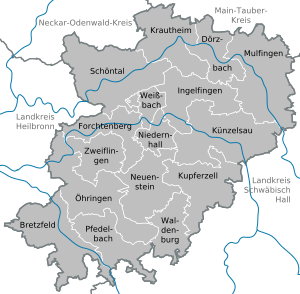
| Capital | Künzelsau |
| Area | |
| • Total | 776.75 km2 (299.90 sq mi) |
| Population (31 December 2017)[1] | |
| • Total | 111,392 |
| • Density | 140/km2 (370/sq mi) |
| Time zone | UTC+01:00 (CET) |
| • Summer (DST) | UTC+02:00 (CEST) |
| Vehicle registration | KÜN, ÖHR |
| Website | http://www.hohenlohekreis.de |
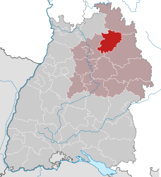
The Hohenlohekreis (German pronunciation: [ˌhoːənˈloːə.kʁaɪs]) is a Landkreis (district) in the north of Baden-Württemberg, Germany. Neighboring districts are (from north clockwise) Neckar-Odenwald, Main-Tauber, Schwäbisch Hall and Heilbronn.
Künzelsau is the administration centre of the district.
Industry and companies
The Hohenlohekreis is host to many internationally active companies in the screws and ventilation industries.
History
The district was created in 1973 by merging the previous districts Öhringen and Künzelsau. It was named after the family of Hohenlohe, who once had ruled most of the area, until 1806 when they lost their independence as this area became part of the kingdom of Württemberg.
Geography
The two main rivers of the districts are the Kocher and Jagst, both affluents to the Neckar. The highest elevation of the district with 523 m is the Mühlberg near Waldenburg.
Partnerships
Since 1990 the district has a partnership with the County Limerick in the Republic of Ireland. In the same year it also started a friendship with the district Großenhain (now Riesa-Großenhain) in the Free State of Saxony, helping to build the administration according to West German standards.
Dialect
The dialect spoken locally is Hohenlohisch, an East Franconian dialect.
Coat of arms
 |
The coat of arms in its top part shows two lions, which is the symbol of the family of Hohenlohe, who once had ruled most of the area. The Wheel of Mainz in bottom is the symbol of the clerical state of Mainz, which also had some possessions around Krautheim. |
Cities and municipalities
| Cities | Administrative districts | Municipalities |
|---|---|---|
|
References
- ↑ "Bevölkerung nach Nationalität und Geschlecht am 31. Dezember 2017". Statistisches Landesamt Baden-Württemberg (in German). 2018.
External links
| Wikimedia Commons has media related to Hohenlohekreis. |
- Official website (German)
- Hohenlohe images (English)(German)
- Map of Hohenlohe areas in the 1780s
Towns and municipalities in Hohenlohe (district) | ||
|---|---|---|