Rock Creek (Palouse River)
| Rock Creek | |
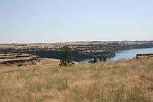
 Rock Creek flows through Hole in the Ground Coulee between Bonnie Lake and Rock Lake. | |
| Country | United States |
|---|---|
| State | Washington |
| County | Spokane, Adams, Whitman |
| Source | Turnbull National Wildlife Refuge |
| - location | Pine Lakes, Spokane County |
| - elevation | 2,226 ft (678 m) [1] |
| - coordinates | 47°23′55″N 117°32′41″W / 47.39861°N 117.54472°W [2] |
| Mouth | Palouse River |
| - location | near Winona, Whitman County |
| - elevation | 1,280 ft (390 m) [2] |
| - coordinates | 46°54′45″N 117°55′41″W / 46.91250°N 117.92806°WCoordinates: 46°54′45″N 117°55′41″W / 46.91250°N 117.92806°W [2] |
| Length | 52 mi (84 km) [3] |
| Basin | 430 sq mi (1,114 km2) [4] |
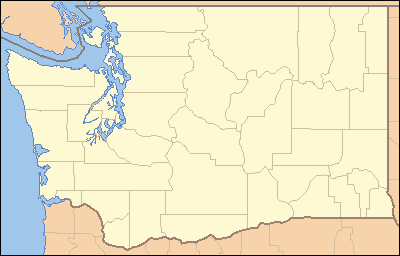 Location of the mouth of Rock Creek in Washington | |
Rock Creek is a tributary of the Palouse River in the U.S. state of Washington. The source of the creek is Pine Lakes in the Turnbull National Wildlife Refuge (TNWR). The creek flows through the TNWR and ultimately joins the Palouse River 6 miles (10 km) downstream from the unincorporated town of Winona, Washington.
Rock Creek drains a basin of 430 square miles (1,100 km2), 13 percent of the Palouse River basin.[4] Rock Creek drains Rock Lake and, upstream from that, Bonnie Lake. Rock Lake has a maximum depth of 350 feet (110 m) and a mean depth of 170 feet (52 m).[5] Lakes within the Rock Creek drainage with managed fisheries include Rock and Bonnie Lakes, and Chapman Lake. Many small lakes in the drainage have no outlets, and some evaporate completely in dry weather.[5]
Geological significance
As Rock Creek crosses the Columbia River Plateau, it passes through the Channeled Scablands, created by the Missoula Floods that swept across eastern Washington during the Pleistocene epoch. The creek follows one of many paths taken by the floods as they cut through the Columbia River Basalt. Notable geologic features in the Rock Creek basin include the scabland and Rock Lake. The creek parallels the adjacent Cow Creek scabland and joins the Palouse River just before it departs Washtucna Coulee, the abandoned flood-scoured course of the river.[6]
Access
The John Wayne Pioneer Trail follows Rock Creek for a portion of the drainage, allowing unique access, particularly to Rock Lake.
See also
References
- ↑ Derived from Google Earth using GNIS coordinates
- 1 2 3 "Rock Creek". Geographic Names Information System. United States Geological Survey. September 10, 1979. Retrieved February 3, 2013.
- ↑ U.S. Geological Survey. National Hydrography Dataset high-resolution flowline data. The National Map, accessed 27 August 2011
- 1 2 Cook, Trevor; et al. "Palouse Subbasin Plan" (PDF). Northwest Power and Conservation Council. pp. 2, 7 (section 1, "Assessment"). Retrieved February 2, 2013.
- 1 2 Cook, Trevor; et al. "Palouse Subbasin Plan" (PDF). Northwest Power and Conservation Council. pp. 71&ndash, 72 (section 1, "Assessment"). Archived from the original (PDF) on February 13, 2012. Retrieved February 3, 2013.
- ↑ Bjornstad, Bruce (2006). On the Trail of the Ice Age Floods: A Geological Guide to the Mid-Columbia Basin. Keokee Books; Sand Point, Idaho. ISBN 978-1-879628-27-4.