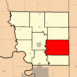
Rochester Township, Andrew County, Missouri
| Rochester Township, Missouri | |
|---|---|
| Township | |
 | |
| Coordinates: 39°55′33″N 094°42′55″W / 39.92583°N 94.71528°WCoordinates: 39°55′33″N 094°42′55″W / 39.92583°N 94.71528°W | |
| Country | United States |
| State | Missouri |
| County | Andrew |
| Area | |
| • Total | 55.97 sq mi (144.97 km2) |
| • Land | 55.40 sq mi (143.49 km2) |
| • Water | 0.57 sq mi (1.48 km2) 1.02% |
| Elevation[1] | 984 ft (300 m) |
| Population (2010) | |
| • Total | 1,182 |
| • Density | 21/sq mi (8.2/km2) |
| FIPS code | 29-62534[2] |
| GNIS feature ID | 0766229 |
Rochester Township is one of ten townships in Andrew County, Missouri, United States. As of the 2010 census, its population was 1,182.[3]
Geography
Rochester Township covers an area of 56.0 square miles (145.0 km2) and contains no incorporated settlements.
The stream of Niagara Creek runs through this township.
References
- ↑ "US Board on Geographic Names". United States Geological Survey. 2007-10-25. Retrieved 2008-01-31.
- ↑ "American FactFinder". United States Census Bureau. Retrieved 2008-01-31.
- ↑ "Geographic Identifiers: 2010 Demographic Profile Data (G001): Rochester township, Andrew County, Missouri". U.S. Census Bureau, American Factfinder. Retrieved June 21, 2013.
External links
Municipalities and communities of Andrew County, Missouri, United States | ||
|---|---|---|
| Cities | 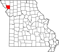 | |
| Villages | ||
| Townships | ||
| Unincorporated communities | ||
| Ghost towns | ||
This article is issued from
Wikipedia.
The text is licensed under Creative Commons - Attribution - Sharealike.
Additional terms may apply for the media files.