Empire Township, Andrew County, Missouri
| Empire Township, Missouri | |
|---|---|
| Township | |
 | |
| Coordinates: 40°00′47″N 094°42′15″W / 40.01306°N 94.70417°WCoordinates: 40°00′47″N 094°42′15″W / 40.01306°N 94.70417°W | |
| Country | United States |
| State | Missouri |
| County | Andrew |
| Area | |
| • Total | 42.67 sq mi (110.52 km2) |
| • Land | 46.19 sq mi (119.62 km2) |
| • Water | 0.35 sq mi (0.90 km2) 0.82% |
| Elevation[1] | 948 ft (289 m) |
| Population (2010) | |
| • Total | 423 |
| • Density | 10/sq mi (3.9/km2) |
| FIPS code | 29-22330[2] |
| GNIS feature ID | 0766222 |
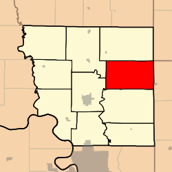
Empire Township is one of ten townships in Andrew County, Missouri, United States. As of the 2010 census, its population was 423.[3]
Geography
Empire Township covers an area of 42.66 square miles (110.5 km2) and contains no incorporated settlements. It contains one cemetery, Bedford Chapel.
The streams of Agee Creek and Crooked Creek run through this township.
References
- ↑ "US Board on Geographic Names". United States Geological Survey. 2007-10-25. Retrieved 2008-01-31.
- ↑ "American FactFinder". United States Census Bureau. Archived from the original on 2013-09-11. Retrieved 2008-01-31.
- ↑ "Geographic Identifiers: 2010 Demographic Profile Data (G001): Empire township, Andrew County, Missouri". U.S. Census Bureau, American Factfinder. Retrieved June 21, 2013.
External links
Municipalities and communities of Andrew County, Missouri, United States | ||
|---|---|---|
| Cities | 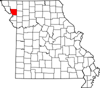 | |
| Villages | ||
| Townships | ||
| Unincorporated communities | ||
| Ghost towns | ||
This article is issued from
Wikipedia.
The text is licensed under Creative Commons - Attribution - Sharealike.
Additional terms may apply for the media files.