Nodaway Township, Andrew County, Missouri
| Nodaway Township | |
|---|---|
| Township | |
 | |
| Coordinates: 39°56′44″N 094°49′39″W / 39.94556°N 94.82750°WCoordinates: 39°56′44″N 094°49′39″W / 39.94556°N 94.82750°W | |
| Country | United States |
| State | Missouri |
| County | Andrew |
| Area | |
| • Total | 39.41 sq mi (102.08 km2) |
| • Land | 39.01 sq mi (101.04 km2) |
| • Water | 0.40 sq mi (1.04 km2) 1.02% |
| Elevation[1] | 1,109 ft (338 m) |
| Population (2010) | |
| • Total | 6,738 |
| • Density | 173/sq mi (66.7/km2) |
| FIPS code | 29-52688[2] |
| GNIS feature ID | 0766227 |
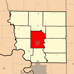
Nodaway Township is one of ten townships in Andrew County, Missouri, United States. As of the 2010 census, its population was 6,738.[3]
Nodaway Township was established in 1846, and named after the Nodaway River.[4]
Geography
Nodaway Township covers an area of 39.4 square miles (102.1 km2) and contains one incorporated settlement, Savannah (the county seat). It contains four cemeteries: Bennett Lane, Coffman, Earls and Kellogg.
The streams of Honey Creek and Lincoln Creek run through this township.
Transportation
Nodaway Township contains one airport, Worth Airport.
References
- ↑ "US Board on Geographic Names". United States Geological Survey. 2007-10-25. Retrieved 2008-01-31.
- ↑ "American FactFinder". United States Census Bureau. Archived from the original on September 11, 2013. Retrieved 2008-01-31.
- ↑ "Geographic Identifiers: 2010 Demographic Profile Data (G001): Nodaway township, Andrew County, Missouri". U.S. Census Bureau, American Factfinder. Retrieved June 21, 2013.
- ↑ "Andrew County Place Names, 1928-1945 (archived)". The State Historical Society of Missouri. Archived from the original on 24 June 2016. Retrieved 30 August 2016.
External links
Municipalities and communities of Andrew County, Missouri, United States | ||
|---|---|---|
| Cities | 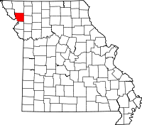 | |
| Villages | ||
| Townships | ||
| Unincorporated communities | ||
| Ghost towns | ||
This article is issued from
Wikipedia.
The text is licensed under Creative Commons - Attribution - Sharealike.
Additional terms may apply for the media files.