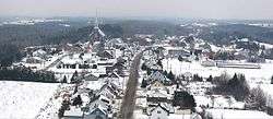
Saint-Paul-de-la-Croix, Quebec
| Saint-Paul-de-la-Croix | |
|---|---|
| Parish municipality | |
 | |
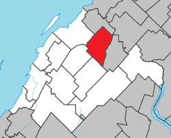 Location within Rivière-du-Loup RCM | |
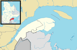 Saint-Paul-de-la-Croix Location in eastern Quebec | |
| Coordinates: 47°57′N 69°12′W / 47.950°N 69.200°WCoordinates: 47°57′N 69°12′W / 47.950°N 69.200°W[1] | |
| Country |
|
| Province |
|
| Region | Bas-Saint-Laurent |
| RCM | Rivière-du-Loup |
| Constituted | January 1, 1873 |
| Government[2] | |
| • Mayor | Philippe Dionne |
| • Federal riding | Montmagny—L'Islet—Kamouraska—Rivière-du-Loup |
| • Prov. riding | Rivière-du-Loup-Témiscouata |
| Area[2][3] | |
| • Total | 85.90 km2 (33.17 sq mi) |
| • Land | 79.56 km2 (30.72 sq mi) |
| Population (2011)[3] | |
| • Total | 367 |
| • Density | 4.6/km2 (12/sq mi) |
| • Pop 2006-2011 |
|
| • Dwellings | 196 |
| Postal code(s) | G0L 3Z0 |
| Area code(s) | 418 and 581 |
| Highways | No major routes |
| Website |
www |
Saint-Paul-de-la-Croix is a parish municipality in Quebec, Canada, in the regional county municipality of Rivière-du-Loup Regional County Municipality and the administrative region of Bas-Saint-Laurent.
See also
References
External links

Adjacent Municipal Subdivisions | ||||||||||
|---|---|---|---|---|---|---|---|---|---|---|
| ||||||||||
| Cities & Towns | |
|---|---|
| Municipalities | |
| Parishes | |
| |
This article is issued from
Wikipedia.
The text is licensed under Creative Commons - Attribution - Sharealike.
Additional terms may apply for the media files.