Causapscal
| Causapscal | |
|---|---|
| City | |
 | |
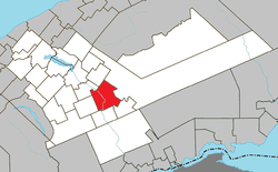 Location within La Matapédia RCM. | |
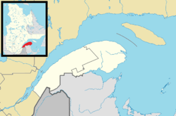 Causapscal Location in eastern Quebec. | |
| Coordinates: 48°22′N 67°14′W / 48.367°N 67.233°WCoordinates: 48°22′N 67°14′W / 48.367°N 67.233°W[1] | |
| Country |
|
| Province |
|
| Region | Bas-Saint-Laurent |
| RCM | La Matapédia |
| Constituted | December 31, 1997 |
| Government[2] | |
| • Mayor | Mario Côté |
| • Federal riding | Avignon—La Mitis—Matane—Matapédia |
| • Prov. riding | Matane-Matapédia |
| Area[2][3] | |
| • Total | 161.00 km2 (62.16 sq mi) |
| • Land | 161.84 km2 (62.49 sq mi) |
|
There is an apparent contradiction between two authoritative sources | |
| Population (2011)[3] | |
| • Total | 2,458 |
| • Density | 15.2/km2 (39/sq mi) |
| • Pop 2006-2011 |
|
| • Dwellings | 1,219 |
| Time zone | UTC−5 (EST) |
| • Summer (DST) | UTC−4 (EDT) |
| Postal code(s) | G0J 1J0 |
| Area code(s) | 418 and 581 |
| Highways |
|
| Website |
www |
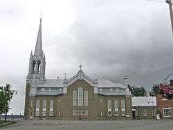
Causapscal (/koʊˈzɑːpskæl/) is a city in the Canadian province of Quebec, located in La Matapédia Regional County Municipality. It is located at the confluence of the Matapédia and Causapscal Rivers, along Quebec Route 132, approximately halfway between Mont-Joli and Campbellton, New Brunswick. It is served by the Causapscal railway station (the town can be reached by Via Rail on the named train The Ocean, between Montreal and Halifax) and the Causapscal Airport.
Etymology
The city's name is taken from the geographic township of Casupscull (proclaimed in 1864), which in turn is derived from the Mi'kmaq word Goesôpsiag (or Gesapsgel, Gesôpsgigel), meaning "stony bottom", "swift water", or "rocky point", likely referring to the rocky river bed of the Causapscal River.[1]
History
Development of the place followed the construction of the Intercolonial Railway in the 1860s. In 1870, the Parish of Saint-Jacques-le-Majeur was established, and the following year, the post office opened.[1][4]
In 1897, the Parish Municipality of Saint-Jacques-le-Majeur-de-Causapscal was incorporated, named after the parish and the geographic township. In 1928, the village itself separated from the parish municipality and was incorporated as the Village Municipality of Causapscal. In 1957, the parish municipality lost more territory when the Municipality of Sainte-Marguerite was formed. In 1965, Causapscal gained ville (city/town) status.[1][4]
On December 31, 1997, the Parish Municipality of Saint-Jacques-le-Majeur-de-Causapscal was amalgamated into the City of Causapscal.[1]
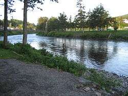
Geography
Causapscal is located in the Matapédia Valley at the confluence of the Matapédia and Causapscal Rivers.
Demographics
Population
| Canada census – Causapscal community profile | |||
|---|---|---|---|
| 2011 | 2006 | ||
| Population: | 2,458 (0.0% from 2006) | 2,458 (-6.7% from 2001) | |
| Land area: | 161.84 km2 (62.49 sq mi) | 161.84 km2 (62.49 sq mi) | |
| Population density: | 15.2/km2 (39/sq mi) | 15.2/km2 (39/sq mi) | |
| Median age: | 49.5 (M: 49.1, F: 49.9) | 45.9 (M: 45.7, F: 46.1) | |
| Total private dwellings: | 1,219 | 1,170 | |
| Median household income: | $37,135 | $34,262 | |
| References: 2011[5] 2006[6] earlier[7] | |||
Canada Census data before 2001 (pre-merger):[8]
|
|
Municipal council
- Mayor: Mario Côté
- Councillors: Renaud Valois, Françoise Jean, Maurice Durette, Élaine Bellavance, Denis Viel, David Desjardins
Notable former residents
- Maurice "Mom" Boucher (born June 21, 1953) Canadian outlaw biker, former President of the Hells Angels' Montreal chapter.
See also
References
- 1 2 3 4 5 "Causapscal (Ville)" (in French). Commission de toponymie du Québec. Retrieved 2012-01-31.
- 1 2 "Causapscal". Répertoire des municipalités (in French). Ministère des Affaires municipales, des Régions et de l'Occupation du territoire. Retrieved 2012-01-31.
- 1 2 "Causapscal census profile". 2011 Census data. Statistics Canada. Retrieved 2012-01-31.
- 1 2 "Saint-Jacques-le-Majeur-de-Causapscal" (in French). Commission de toponymie du Québec. Retrieved 2012-02-01.
- ↑ "2011 Community Profiles". Canada 2011 Census. Statistics Canada. July 5, 2013. Retrieved 2014-02-01.
- ↑ "2006 Community Profiles". Canada 2006 Census. Statistics Canada. March 30, 2011. Retrieved 2012-01-30.
- ↑ "2001 Community Profiles". Canada 2001 Census. Statistics Canada. February 17, 2012.
- ↑ "Electronic Area Profiles". Canada 1996 Census. Statistics Canada. Retrieved 2013-05-10.
External links
| Wikimedia Commons has media related to Causapscal. |
- (in French) Ville de Causapscal
Adjacent Municipal Subdivisions | |
|---|---|
| Cities & Towns | |
|---|---|
| Municipalities | |
| Parishes | |
| Villages | |
| Unorganized territories | |
| |