Rio Grande, New Jersey
| Rio Grande, New Jersey | |
|---|---|
| Census-designated place | |
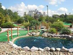 Putt-putt golf course | |
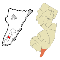 Map of Rio Grande highlighted within Cape May County. Right: Location of Cape May County in New Jersey. | |
| Coordinates: 39°01′09″N 74°52′40″W / 39.019051°N 74.87787°WCoordinates: 39°01′09″N 74°52′40″W / 39.019051°N 74.87787°W | |
| Country |
|
| State |
|
| County | Cape May |
| Township | Middle |
| Area[1] | |
| • Total | 2.490 sq mi (6.450 km2) |
| • Land | 2.459 sq mi (6.369 km2) |
| • Water | 0.031 sq mi (0.081 km2) 1.26% |
| Elevation[2] | 20 ft (6 m) |
| Population (2010 Census)[3] | |
| • Total | 2,670 |
| • Density | 1,085.8/sq mi (419.2/km2) |
| Time zone | UTC-5 (Eastern (EST)) |
| • Summer (DST) | UTC-4 (Eastern (EDT)) |
| ZIP code | 08242[4] |
| Area code(s) | 609 |
| FIPS code | 3463180[5] |
| GNIS feature ID | 02389752[6] |
Rio Grande (/rioʊɡrʌndeɪ/) is an unincorporated community and census-designated place (CDP) located within Middle Township in Cape May County, New Jersey, United States.[7] Though located within Middle Township,[8] a small section at the southern edge of the community, located in Lower Township, is sometimes called Rio Grande.[9][10] It is part of the Ocean City Metropolitan Statistical Area. As of the 2010 United States Census, the CDP's population was 2,670.[3]
History
According to Jeffrey M. Dorwart, Rio Grande was founded in the mid-nineteenth century around a country store owned by the Hildreth family. The community was originally called Hildreth for that reason.[11]
George F. Boyer and J. Pearson Cunningham explain that, during the colonial period, Aaron Leaming, the Hildreths and the Cresses had plantations in that area. Where the King's Highway crossed the road coming from Dennisville and Goshen a stage coach terminal was set up, and the spot became the center for trade for the local farming families. Boyer and Cunningham say that the area was known as "Leamings," for the prominent landholders, or as "Hildreth," the family who ran the local store. (p. 121-122) They continue, "The name, Rio Grande, was suggested by the seventh Aaron Leaming who thought this southern United States river had an attractive sound."[12]
Geography
According to the United States Census Bureau, the CDP had a total area of 2.490 square miles (6.450 km2), including 2.459 square miles (6.369 km2) of land and 0.031 square miles (0.081 km2) of water (1.26%).[1][13]
Climate
The climate in this area is characterized by hot, humid summers and generally mild to cool winters. According to the Köppen Climate Classification system, Rio Grande has a humid subtropical climate, abbreviated "Cfa" on climate maps.[14]
Demographics
| Historical population | |||
|---|---|---|---|
| Census | Pop. | %± | |
| 1990 | 2,505 | — | |
| 2000 | 2,444 | −2.4% | |
| 2010 | 2,670 | 9.2% | |
| Population sources: 2000[15] 2010[3] | |||
Census 2010
As of the 2010 United States Census, there were 2,670 people, 1,115 households, and 730.3 families residing in the CDP. The population density was 1,085.8 per square mile (419.2/km2). There were 1,489 housing units at an average density of 605.5 per square mile (233.8/km2). The racial makeup of the CDP was 86.44% (2,308) White, 5.54% (148) Black or African American, 0.26% (7) Native American, 2.51% (67) Asian, 0.04% (1) Pacific Islander, 3.22% (86) from other races, and 1.99% (53) from two or more races. Hispanic or Latino of any race were 7.68% (205) of the population.[3]
There were 1,115 households out of which 20.8% had children under the age of 18 living with them, 45.4% were married couples living together, 13.6% had a female householder with no husband present, and 34.5% were non-families. 29.1% of all households were made up of individuals, and 12.8% had someone living alone who was 65 years of age or older. The average household size was 2.37 and the average family size was 2.85.[3]
In the CDP, the population was spread out with 18.4% under the age of 18, 8.0% from 18 to 24, 22.3% from 25 to 44, 31.0% from 45 to 64, and 20.3% who were 65 years of age or older. The median age was 45.9 years. For every 100 females there were 97.6 males. For every 100 females ages 18 and older there were 96.4 males.[3]
Census 2000
As of the 2000 United States Census[5] there were 2,444 people, 1,029 households, and 658 families residing in the CDP. The population density was 399.8/km2 (1,036.8/mi2). There were 1,294 housing units at an average density of 211.7/km2 (548.9/mi2). The racial makeup of the CDP was 90.79% White, 4.50% African American, 0.29% Native American, 0.94% Asian, 1.10% from other races, and 2.37% from two or more races. Hispanic or Latino of any race were 3.03% of the population.[15]
There are 1,029 households, out of which 25.5% have children under the age of 18 living with them; 46.6% are married couples living together; 13.6% have a female householder with no husband present; and 36.0% were non-families. 30.1% of all households were made up of individuals and 15.4% had someone living alone who was 65 years of age or older. The average household size was 2.36 and the average family size was 2.93.[15]
In the CDP the population was spread out with 21.6% under the age of 18, 7.7% from 18 to 24, 26.7% from 25 to 44, 24.1% from 45 to 64, and 19.9% who were 65 years of age or older. The median age was 42 years. For every 100 females, there were 91.7 males. For every 100 females age 18 and over, there were 91.8 males.[15]
The median income for a household in the CDP was $28,424, and the median income for a family was $38,007. Males had a median income of $32,935 versus $19,643 for females. The per capita income for the CDP was $18,792. About 20.9% of families and 21.4% of the population were below the poverty line, including 32.5% of those under age 18 and 17.9% of those age 65 or over.[15]
Education
The areas within Middle Township, including Rio Grande CDP, are in the Middle Township Public Schools; it operates Middle Township High School.
Areas with Rio Grande addresses in Lower Township are in the Lower Township School District for elementary grades and the Lower Cape May Regional School District for secondary grades; the latter operates Lower Cape May Regional High School.
Transportation
Rio Grande is situated at the junction of U.S. Route 9 and Route 47. U.S. Route 9 runs south to Cape May and north toward the Atlantic City area while Route 47 runs southeast to Wildwood and north to Millville and the Camden area. Rio Grande is accessible from the Garden State Parkway at exit 4 northbound and exit 4B southbound.[16]
NJ Transit offers bus service from Rio Grande to Cape May and Philadelphia on the 313, 315 and 316 (seasonal only) routes, to Cape May and the Port Authority Bus Terminal in Midtown Manhattan on the 319 route, to Wildwood on the 510 route, and to Cape May and Atlantic City on the 552 route.[17][18]
The Great American Trolley Company operates trolley service from North Wildwood and Wildwood to shopping centers in Rio Grande on Mondays through Fridays in the summer months.[19]
Cape May Airport, established in 1941 as NAS Rio Grande, is located in the area,[8] in adjacent Lower Township.[20][21]
Wineries and breweries
- Cape May Brewing Company
- Hawk Haven Vineyard & Winery
- 7 Mile Brewery
Gallery
 Rio Grande Post Office
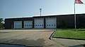 Rio Grande Fire Station
References
- 1 2 Gazetteer of New Jersey Places, United States Census Bureau. Accessed July 21, 2016.
- ↑ U.S. Geological Survey Geographic Names Information System: Rio Grande Census Designated Place, Geographic Names Information System. Accessed October 18, 2012.
- 1 2 3 4 5 6 DP-1 - Profile of General Population and Housing Characteristics: 2010 Demographic Profile Data for Rio Grande CDP, New Jersey, United States Census Bureau. Accessed October 18, 2012.
- ↑ Look Up a ZIP Code for Rio Grande, NJ, United States Postal Service. Accessed October 18, 2012.
- 1 2 American FactFinder, United States Census Bureau. Accessed September 4, 2014.
- ↑ US Board on Geographic Names, United States Geological Survey. Accessed September 4, 2014.
- ↑ New Jersey: 2010 - Population and Housing Unit Counts - 2010 Census of Population and Housing (CPH-2-32), United States Census Bureau, August 2012. Accessed October 18, 2012.
- 1 2 Linehan, Mary. "Air station looks to solve identity crisis" Archived 2013-10-29 at the Wayback Machine., The Cape May Gazette, April 30, 2013. Accessed May 4, 2013. "According to the DRBA maintained website for the Cape May Airport, 'this well-maintained 1,000-acre general aviation airport' is located in Rio Grande, New Jersey, approximately five miles from Cape May. The site does list the airport's address as being in Erma. Rio Grande is part of Middle Township and Erma is in Lower Township."
- ↑ DeAngelis, Martin. "Dine among the vineyards on local fare at Hawk Haven" in The Press of Atlantic City, May 18, 2011. Accessed May 4, 2013.
- ↑ Locality Search, State of New Jersey. Accessed April 19, 2015.
- ↑ Dorwart, Jeffrey M. Cape May County, New Jersey: The Making of an American Resort Community, p. 154, (New Brunswick: Rutgers University Press, 1992). ISBN 9780813517841. Accessed July 22, 2016.
- ↑ Boyer, George F.; and Cunningham, J. Pearson Cape May County Story (Egg Harbor City, NJ: The Laureate Press, 1975).
- ↑ US Gazetteer files: 2010, 2000, and 1990, United States Census Bureau. Accessed September 4, 2014.
- ↑ Climate Summary for Rio Grande, New Jersey
- 1 2 3 4 5 DP-1 - Profile of General Demographic Characteristics: 2000 from the Census 2000 Summary File 1 (SF 1) 100-Percent Data for Rio Grande CDP, New Jersey, United States Census Bureau. Accessed October 18, 2012.
- ↑ New Jersey State Transportation Map, New Jersey Department of Transportation, 2012. Accessed May 26, 2016.
- ↑ Cape May Bus / Rail Connections, NJ Transit, backed up by the Internet Archive as of January 28, 2010. Accessed October 2, 2014.
- ↑ South Jersey Transit Guide, Cross County Connection, as of April 1, 2010. Accessed October 2, 2014.
- ↑ "North Wildwood-Wildwood Crest-Rio Grande (Walmart)". Great American Trolley Company. Retrieved August 7, 2017.
- ↑ "2010 CENSUS - CENSUS BLOCK MAP (INDEX): Lower township, NJ." U.S. Census Bureau. Retrieved on August 15, 2018. Pages: 1, 2, 3, and 4.
- ↑ "Airport Operations." Cape May Airport. Retrieved on August 15, 2018. "Cape May Airport (WWD) 507 Terminal Drive, Bldg. 102 Rio Grande, NJ 08242"
External links
- The Cape May County Gazette Local community newspaper
- The Beachcomber
- Cape May County Herald
Municipalities and communities of Cape May County, New Jersey, United States | ||
|---|---|---|
| Cities | 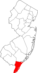 | |
| Boroughs | ||
| Townships | ||
| CDPs | ||
| Other unincorporated communities | ||