Rio, Wisconsin
| Rio, Wisconsin | |
|---|---|
| Village | |
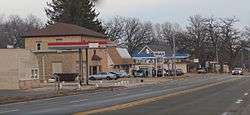 Looking east in downtown Rio on WIS 16 | |
| Nickname(s): R-10 | |
 Location of Rio in Columbia County, Wisconsin. | |
| Coordinates: 43°26′52″N 89°14′26″W / 43.44778°N 89.24056°WCoordinates: 43°26′52″N 89°14′26″W / 43.44778°N 89.24056°W | |
| Country | United States |
| State | Wisconsin |
| County | Columbia |
| Area[1] | |
| • Total | 6.41 sq mi (16.60 km2) |
| • Land | 6.01 sq mi (15.58 km2) |
| • Water | 0.40 sq mi (1.03 km2) |
| Elevation[2] | 932 ft (284 m) |
| Population (2010)[3] | |
| • Total | 1,059 |
| • Estimate (2016)[4] | 1,046 |
| • Density | 173.90/sq mi (67.14/km2) |
| Time zone | UTC-6 (Central (CST)) |
| • Summer (DST) | UTC-5 (CDT) |
| ZIP code | 53960 |
| Area code(s) | 920 |
| FIPS code | 55-68100[5] |
| GNIS feature ID | 1572330[2] |
| Website | www.riowi.us |
Rio /ˈraɪ.oʊ/[6] (pronounced "rye-oh") is a village in Columbia County, Wisconsin, United States. The population was 1,059 at the 2010 census. It is part of the Madison Metropolitan Statistical Area. The village rests primarily in the town of Otsego. The Village of Rio calls itself "Camper Country USA" due to several campgrounds located near the village. Rio is halfway between Columbus and Portage on Highway 16.
Geography
Rio is located at 43°26′52″N 89°14′26″W / 43.44778°N 89.24056°W (43.447914, -89.240557).[7]
According to the United States Census Bureau, the village has a total area of 1.27 square miles (3.29 km2), of which, 1.26 square miles (3.26 km2) of it is land and 0.01 square miles (0.03 km2) is water.[8]
Demographics
| Historical population | |||
|---|---|---|---|
| Census | Pop. | %± | |
| 1870 | 300 | — | |
| 1880 | 230 | −23.3% | |
| 1890 | 339 | 47.4% | |
| 1900 | 479 | 41.3% | |
| 1910 | 704 | 47.0% | |
| 1920 | 620 | −11.9% | |
| 1930 | 641 | 3.4% | |
| 1940 | 696 | 8.6% | |
| 1950 | 741 | 6.5% | |
| 1960 | 788 | 6.3% | |
| 1970 | 792 | 0.5% | |
| 1980 | 785 | −0.9% | |
| 1990 | 768 | −2.2% | |
| 2000 | 938 | 22.1% | |
| 2010 | 1,059 | 12.9% | |
| Est. 2016 | 1,046 | [4] | −1.2% |
| U.S. Decennial Census[9] | |||
2010 census
As of the census[3] of 2010, there were 1,059 people, 436 households, and 292 families residing in the village. The population density was 840.5 inhabitants per square mile (324.5/km2). There were 475 housing units at an average density of 377.0 per square mile (145.6/km2). The racial makeup of the village was 97.7% White, 0.2% African American, 0.2% Native American, 0.3% Asian, 0.1% Pacific Islander, 0.3% from other races, and 1.2% from two or more races. Hispanic or Latino of any race were 1.4% of the population.
There were 436 households of which 36.0% had children under the age of 18 living with them, 51.1% were married couples living together, 9.4% had a female householder with no husband present, 6.4% had a male householder with no wife present, and 33.0% were non-families. 27.1% of all households were made up of individuals and 13.3% had someone living alone who was 65 years of age or older. The average household size was 2.43 and the average family size was 2.96.
The median age in the village was 35.8 years. 26.7% of residents were under the age of 18; 6.4% were between the ages of 18 and 24; 29.9% were from 25 to 44; 23.7% were from 45 to 64; and 13.3% were 65 years of age or older. The gender makeup of the village was 48.4% male and 51.6% female.
2000 census
As of the census[5] of 2000, there were 938 people, 379 households, and 258 families residing in the village. The population density was 751.4 people per square mile (289.7/km²). There were 401 housing units at an average density of 321.2 per square mile (123.9/km²). The racial makeup of the village was 98.08% White, 0.11% African American, 0.21% Native American, 0.75% from other races, and 0.85% from two or more races. Hispanic or Latino of any race were 1.71% of the population.
There were 379 households out of which 35.4% had children under the age of 18 living with them, 54.9% were married couples living together, 9.0% had a female householder with no husband present, and 31.9% were non-families. 26.1% of all households were made up of individuals and 10.8% had someone living alone who was 65 years of age or older. The average household size was 2.45 and the average family size was 2.95.
In the village, the population was spread out with 25.3% under the age of 18, 6.6% from 18 to 24, 33.0% from 25 to 44, 18.4% from 45 to 64, and 16.6% who were 65 years of age or older. The median age was 38 years. For every 100 females, there were 95.4 males. For every 100 females age 18 and over, there were 94.7 males.
The median income for a household in the village was $42,292, and the median income for a family was $49,500. Males had a median income of $34,118 versus $26,023 for females. The per capita income for the village was $17,668. About 3.1% of families and 4.9% of the population were below the poverty line, including 3.3% of those under age 18 and 8.3% of those age 65 or over.
Economy
Rio is home to a variety of thriving businesses including several banks, a small town market, a specialty meat shop/butcher, pharmacy, and a bowling alley.
- Johnson's Sausage Shoppe & Catering, butcher shop carrying a variety of specialty meats, cheeses, alcohol, and other foods[10]
- Mark's Market, small town grocery and household items store with a healthy variety for its size
- Rio Hometown Pharmacy, full service Pharmacy, gift store, and coffee house[11]
- Rio Shopper, local newspaper with ads, classifieds, announcements, and regional news[12]
- Old Theater Restaurant & Bar, full service restaurant and bar located downtown with pizza delivery
- Mobil Gas Station, 24hr pay at the pump, diesel pumps, minimart, and food counter inside; located on Highway 16
- Rio Lanes, full size lanes bowling alley located downtown
- Farmers and Merchants Union Bank, branch bank that is headquartered in Columbus, WI
Civic Organizations
- Rio American Legion Post 208, located one block east of downtown on East Harvey Street
- Rio Conservation Club, dedicated to the preservation of wildlife and nature
- Rio Community Club, promoting community and local business
Transportation
Gilbert Field airport (94C) is a public use grass field with one east-west runway (9/27). The field is privately owned and operated by Rio Aero Club Inc. Every year the Rio Aero Club Inc. hosts a fly-in breakfast. CTAF 122.9
Notable people
- Debbie McCormick, Olympic Curling
Images
 The sign for Rio, Wisconsin on County Highway B
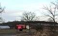 Rio High School
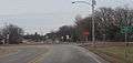
 Looking west in downtown Rio, Wisconsin on Wisconsin Highway 16
References
- ↑ "2016 U.S. Gazetteer Files". United States Census Bureau. Retrieved Jul 14, 2017.
- 1 2 "US Board on Geographic Names". United States Geological Survey. 2007-10-25. Retrieved 2008-01-31.
- 1 2 "American FactFinder". United States Census Bureau. Retrieved 2012-11-18.
- 1 2 "Population and Housing Unit Estimates". Retrieved June 9, 2017.
- 1 2 "American FactFinder". United States Census Bureau. Retrieved 2008-01-31.
- ↑ Miss Pronouncer: Hear how to pronounce; The Wisconsin pronunciation guide for cities, counties, Indians & lawmakers
- ↑ "US Gazetteer files: 2010, 2000, and 1990". United States Census Bureau. 2011-02-12. Retrieved 2011-04-23.
- ↑ "US Gazetteer files 2010". United States Census Bureau. Archived from the original on 2012-01-24. Retrieved 2012-11-18.
- ↑ "Census of Population and Housing". Census.gov. Retrieved June 4, 2015.
- ↑ "Company Website - Johnson's Sausage Shoppe".
- ↑ "Rio Hometown Pharmacy Website".
- ↑ "The Rio Shopper Website".
External links
| Wikimedia Commons has media related to Rio, Wisconsin. |
Municipalities and communities of Columbia County, Wisconsin, United States | ||
|---|---|---|
| Cities | 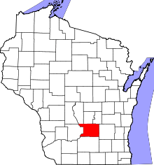 | |
| Villages | ||
| Towns | ||
| CDP | ||
| Unincorporated communities | ||
| Ghost town/neighborhood | ||
| Footnotes | ‡This populated place also has portions in an adjacent county or counties | |