Riepetown, Nevada
| Riepetown, Nevada | |
|---|---|
| Unincorporated community | |
 Riepetown, Nevada | |
| Coordinates: 39°15′52″N 115°0′39″W / 39.26444°N 115.01083°WCoordinates: 39°15′52″N 115°0′39″W / 39.26444°N 115.01083°W | |
| Country | United States |
| State | Nevada |
| County | White Pine |
| Elevation | 7,100 ft (2,200 m) |
| GNIS feature ID | 856354 |
Riepetown is an unincorporated community in the White Pine County in Nevada, United States.[1] Riepetown is located on former State Route 485, 3 miles southwest of its junction with U.S. Route 50; 5 miles northwest of Ely.[2]
History
Riepetown was named for Richard A. Riepe, a first-generation German immigrant who surveyed the land in this area. Riepe was later elected to the Nevada Assembly, representing Lincoln County in 1883 and White Pine County in 1889.[3]
Riepetown was not a company town and thus played host to businesses banned in other mining communities, such as brothels and saloons. It was decimated by a massive fire in 1917, and though portions were rebuilt, the town gradually depopulated.[3]
Notes
Municipalities and communities of White Pine County, Nevada, United States | ||
|---|---|---|
| City | 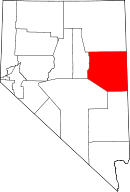 | |
| CDPs | ||
| Other unincorporated communities |
| |
| Indian reservations | ||
| Ghost towns | ||
| Footnotes | ‡This populated place also has portions in an adjacent county or counties | |
This article is issued from
Wikipedia.
The text is licensed under Creative Commons - Attribution - Sharealike.
Additional terms may apply for the media files.