Preston, Nevada
| Preston, Nevada | |
|---|---|
| Census-designated place | |
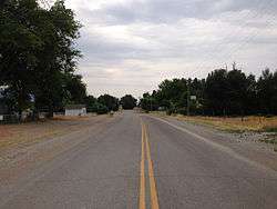 SR 895 in Preston | |
 Preston Location within the state of Nevada | |
| Coordinates: 38°54′49″N 115°3′38″W / 38.91361°N 115.06056°W | |
| Country | United States |
| State | Nevada |
| County | White Pine |
| Area | |
| • Total | 1.2 sq mi (3.1 km2) |
| • Land | 1.2 sq mi (3.1 km2) |
| • Water | 0 sq mi (0 km2) |
| Elevation | 5,636 ft (1,718 m) |
| Population (2010) | |
| • Total | 78 |
| • Density | 65/sq mi (25/km2) |
| Time zone | UTC-8 (Pacific (PST)) |
| • Summer (DST) | UTC-7 (PDT) |
| FIPS code | 32-58000 |
| GNIS feature ID | 0845604 |
Preston is a census-designated place in White Pine County, Nevada, United States. Preston was established by Mormon settlers in 1876, and named after William B. Preston, the fourth Presiding Bishop of The Church of Jesus Christ of Latter-day Saints between 1884 and 1907.[1] The community's economy is based on agriculture and ranching. Preston is at an elevation of 5,636 feet (1,718 m). In the 2010 census it had a population of 78.[2]
References
- ↑ Hall, Shawn (1994). Romancing Nevada's Past: Ghost Towns and Historic Sites of Eureka, Lander, and White Pine Counties. Reno NV: University of Nevada Press. p. 177. ISBN 9780874172287. Retrieved 30 September 2014.
- ↑ "Geographic Identifiers: 2010 Demographic Profile Data (G001): Preston CDP, Nevada". U.S. Census Bureau, American Factfinder. Retrieved January 28, 2013.
Municipalities and communities of White Pine County, Nevada, United States | ||
|---|---|---|
| City | 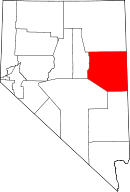 | |
| CDPs | ||
| Other unincorporated communities |
| |
| Indian reservations | ||
| Ghost towns | ||
| Footnotes | ‡This populated place also has portions in an adjacent county or counties | |
This article is issued from
Wikipedia.
The text is licensed under Creative Commons - Attribution - Sharealike.
Additional terms may apply for the media files.