Rhode Island Route 146
| ||||
|---|---|---|---|---|
| Worcester–Providence Turnpike | ||||
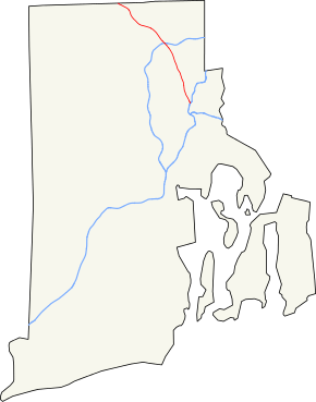 Map of Rhode Island with Route 146 in red. | ||||
| Route information | ||||
| Maintained by RIDOT | ||||
| Length | 16.24 mi[1] (26.14 km) | |||
| Major junctions | ||||
| South end |
| |||
|
| ||||
| North end |
| |||
| Location | ||||
| Counties | Providence | |||
| Highway system | ||||
| ||||

Route 146, also known as the Louisquisset Pike, the Eddie Dowling Highway, and the North Smithfield Expressway, is a 16.24-mile (26.14 km) long numbered state highway located in Providence County, Rhode Island, United States. The route is a major north–south freeway in the northern Providence metropolitan area, directly linking Providence with the cities of Woonsocket, Rhode Island and Worcester, Massachusetts. For most of its length, Route 146 is a limited-access freeway, although there is one traffic signal in the North Smithfield business district. The southern terminus of the freeway is at Interstate 95 in downtown Providence, and the route's northern terminus is at the Rhode Island-Massachusetts state line in Millville, where it continues northward towards the Massachusetts Turnpike and the city of Worcester as Massachusetts Route 146.
Route description
Route 146 takes the following route through the State:
- Providence: 2.4 miles (3.9 km); Interstate 95 to North Providence town line.
- Louisquisset Pike
- North Providence: 1.1 miles (1.8 km); Providence city line to Lincoln town line.
- Louisquisset Pike
- Lincoln: 7.5 miles (12.1 km); North Providence town line to North Smithfield town line.
- Eddie Dowling Highway
- North Smithfield: 6.3 miles (10.1 km); Lincoln town line to Massachusetts state line at Route 146.
- North Smithfield Expressway
Route 146 is a freeway for its entire length except for one traffic light in the North Smithfield business district.[2]
History
Prior to the construction of the freeway, Route 146 used present-day Route 246 and Route 146A. Part of the original alignment, between Interstate 295 and Route 99, was upgraded on the spot.
There is a section of original alignment north of Route 116 on the west side of Route 146 running parallel to the freeway.
Exit list
All exits are mile-based, whereas most other highways in Rhode Island use sequential numbering Mileposts listed are based on NB mileposts; SB mileposts reflect distance from MA border. The entire route is in Providence County.
| Location | mi[1] | km | Exit | Destinations | Notes |
|---|---|---|---|---|---|
| Providence | 0.00 | 0.00 | Southern terminus, exit 23 (I-95) | ||
| 0.40 | 0.64 | Southbound entrance only, all other access via I-95 exit 23 | |||
| 0.30 | 0.48 | 1A | Southbound exit and northbound entrance | ||
| 1.40 | 2.25 | 1 (NB) 1B (SB) | Branch Avenue | ||
| North Providence | 2.50 | 4.02 | 2 | No northbound entrance | |
| 2.90 | 4.67 | Entrance ramps only | |||
| Lincoln | 4.00 | 6.44 | 4A | Southbound exit only | |
| 4.50 | 7.24 | 4 NB 4B SB | Twin River Road | ||
| 5.00 | 8.05 | 5 | |||
| 6.40 | 10.30 | 6 | NB: Sherman Avenue SB: | ||
| 6.70 | 10.78 | Wilbur Road | Northbound entrance only | ||
| 7.40 | 11.91 | 7 NB A-B SB | Split into separate north and south exits southbound. Southbound exit to 116 South also provides access to Old Louisquisset Pike, and is accessed from c/d road shared with I-295 Exits | ||
| 8.50 | 13.68 | 8 A-B | Exit 18 on I-295 | ||
| 8.80 | 14.16 | 8C | Northbound exit and southbound entrance. Accessed from c/d road shared with I-295 Exits | ||
| 8.90 | 14.32 | North end of freeway | |||
| 9.00 | 14.48 | 9A | NB: Old Great Road SB: Reservoir Road | Interchange, no northbound exit | |
| 9.70 | 15.61 | 9B | At-grade Intersection | ||
| North Smithfield | 10.50 | 16.90 | 10 | Sayles Hill Road | Interchange, southbound exit and entrance |
| 10.60 | 17.06 | 10 | Northbound exit and southbound entrance, southbound access via u-turn | ||
| 10.70 | 17.22 | South end of freeway | |||
| 12.10 | 19.47 | 12 | |||
| 13.40 | 21.57 | 13 | Pound Hill Road | ||
| 14.30 | 23.01 | 14 | Via Route 146A | ||
| 16.24 | 26.14 | Continuation into Massachusetts | |||
| 1.000 mi = 1.609 km; 1.000 km = 0.621 mi | |||||
See also
References
- 1 2 Google (December 31, 2013). "Route 146" (Map). Google Maps. Google. Retrieved December 31, 2013.
- ↑ "146, Worcester Providence Turnpike". Boston Roads.com. Retrieved 2008-01-14.
Route map: