Reynoldsville, West Virginia
| Reynoldsville, West Virginia | |
|---|---|
| Unincorporated community | |
 Reynoldsville  Reynoldsville | |
| Coordinates: 39°17′18″N 80°26′05″W / 39.28833°N 80.43472°WCoordinates: 39°17′18″N 80°26′05″W / 39.28833°N 80.43472°W | |
| Country | United States |
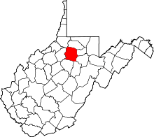
| State | West Virginia |
| County | Harrison |
| Elevation | 1,056 ft (322 m) |
| Time zone | UTC-5 (Eastern (EST)) |
| • Summer (DST) | UTC-4 (EDT) |
| ZIP code | 26422 |
| Area code(s) | 304 & 681 |
| GNIS feature ID | 1555468[1] |
Reynoldsville is an unincorporated community in Harrison County, West Virginia, United States. Reynoldsville is 5 miles (8.0 km) west of Clarksburg. Reynoldsville has a post office with ZIP code 26422.[2]
The community was named after Thomas Philip Reynolds, an early settler.[3]
References
- ↑ "US Board on Geographic Names". United States Geological Survey. 2007-10-25. Retrieved 2008-01-31.
- ↑ ZIP Code Lookup
- ↑ Kenny, Hamill (1945). West Virginia Place Names: Their Origin and Meaning, Including the Nomenclature of the Streams and Mountains. Piedmont, WV: The Place Name Press. p. 529.
This article is issued from
Wikipedia.
The text is licensed under Creative Commons - Attribution - Sharealike.
Additional terms may apply for the media files.