Goodhope, West Virginia
| Goodhope, West Virginia | |
|---|---|
| Unincorporated community | |
 Goodhope  Goodhope | |
| Coordinates: 39°10′53″N 80°26′21″W / 39.18139°N 80.43917°WCoordinates: 39°10′53″N 80°26′21″W / 39.18139°N 80.43917°W | |
| Country | United States |
| State | West Virginia |
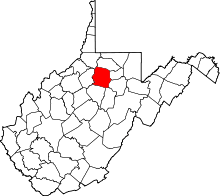
| County | Harrison |
| Elevation | 1,020 ft (310 m) |
| Time zone | UTC-5 (Eastern (EST)) |
| • Summer (DST) | UTC-4 (EDT) |
| Area code(s) | 304 & 681 |
| GNIS feature ID | 1554579[1] |
Goodhope[1] is an unincorporated community in Harrison County, West Virginia, United States. Goodhope is located along U.S. Route 19 and the West Fork River 2.3 miles (3.7 km) southwest of West Milford.[2]
References
- 1 2 "Goodhope". Geographic Names Information System. United States Geological Survey.
- ↑ Harrison County, West Virginia General Highway Map (PDF) (Map). West Virginia Department of Transportation. 2011. p. 2. Retrieved June 29, 2012.
This article is issued from
Wikipedia.
The text is licensed under Creative Commons - Attribution - Sharealike.
Additional terms may apply for the media files.