Retrop, Oklahoma
| Retrop | |
|---|---|
| Unincorporated community | |
 Retrop Location within the state of Oklahoma  Retrop Retrop (the US) | |
| Coordinates: 35°9′35″N 99°21′35″W / 35.15972°N 99.35972°WCoordinates: 35°9′35″N 99°21′35″W / 35.15972°N 99.35972°W | |
| Country | United States |
| State | Oklahoma |
| County | Washita and Beckham |
| Time zone | UTC-6 (Central (CST)) |
| • Summer (DST) | UTC-5 (CDT) |
Retrop is a small Oklahoma, USA community located on the Washita/Beckham county line. It is located at the southern junction between State Highway 6 and SH-55.[1] Retrop receives its name from the original community (Old Retrop, 35°08′43″N 99°20′33″W / 35.145331°N 99.342585°W) which is one mile south and one mile east in Washita County near the Retrop Cemetery. The Retrop Post Office (located at Old Retrop) existed from January 12, 1900, until February 28, 1905. The name is a reverse spelling of the surname of the first postmaster, Ira J. Porter.[2]
See also
References
Municipalities and communities of Washita County, Oklahoma, United States | ||
|---|---|---|
| Cities | 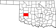 | |
| Towns | ||
| Unincorporated communities |
| |
| Footnotes | ‡This populated place also has portions in an adjacent county or counties | |
Municipalities and communities of Beckham County, Oklahoma, United States | ||
|---|---|---|
| Cities | 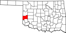 | |
| Towns | ||
| Unincorporated communities | ||
| Footnotes | ‡This populated place also has portions in an adjacent county or counties | |
This article is issued from
Wikipedia.
The text is licensed under Creative Commons - Attribution - Sharealike.
Additional terms may apply for the media files.