Hext, Oklahoma
| Hext | |
|---|---|
| Unincorporated community | |
 Hext Location within the state of Oklahoma  Hext Hext (the US) | |
| Coordinates: 35°14′51″N 99°45′10″W / 35.24750°N 99.75278°WCoordinates: 35°14′51″N 99°45′10″W / 35.24750°N 99.75278°W | |
| Country | United States |
| State | Oklahoma |
| County | Beckham |
| Elevation[1] | 1,923 ft (586 m) |
| Time zone | UTC-6 (Central (CST)) |
| • Summer (DST) | UTC-5 (CDT) |
Hext is a small unincorporated rural community on old U.S. Highway 66 in Beckham County, Oklahoma, United States. The town was named after a local resident, William Hext.[2]
History and economy
It had a post office from June 4, 1901, until November 29, 1902.[2]
The stone gas station on Old Route 66 was converted into a home and the pumps were removed.
There are no businesses in this area. The major economic activities in the area are horse breeding and farming.
References
- ↑ GNIS coordinates and elevation
- 1 2 Shirk, George H. Oklahoma Place Names, Norman, Oklahoma: University of Oklahoma Press, 1965, p.73.
Municipalities and communities of Beckham County, Oklahoma, United States | ||
|---|---|---|
| Cities | 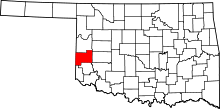 | |
| Towns | ||
| Unincorporated communities | ||
| Footnotes | ‡This populated place also has portions in an adjacent county or counties | |
This article is issued from
Wikipedia.
The text is licensed under Creative Commons - Attribution - Sharealike.
Additional terms may apply for the media files.