Port, Oklahoma
| Port | |
|---|---|
| Unincorporated community | |
 Port Location within the state of Oklahoma  Port Port (the US) | |
| Coordinates: 35°12′16″N 99°18′26″W / 35.20444°N 99.30722°WCoordinates: 35°12′16″N 99°18′26″W / 35.20444°N 99.30722°W | |
| Country | United States |
| State | Oklahoma |
| County | Washita |
| Time zone | UTC-6 (Central (CST)) |
| • Summer (DST) | UTC-5 (CDT) |
Port is a small rural community in Washita County, Oklahoma. The community had a post office from February 21, 1901, until February 29, 1940. It was named for a druggist, Mrs. F. M. Port. During the 1930s, the Port consolidated school district covered the largest area in Oklahoma, some ninety square miles.
Prior to settlement, the Western Cattle Trail passed just east of the site.
The community lends its name to the Oklahoma state soil, Port Silt Loam.
See also
External links
- Port, Oklahoma – RootsWeb.com
Municipalities and communities of Washita County, Oklahoma, United States | ||
|---|---|---|
| Cities | 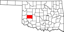 | |
| Towns | ||
| Unincorporated communities |
| |
| Footnotes | ‡This populated place also has portions in an adjacent county or counties | |
This article is issued from
Wikipedia.
The text is licensed under Creative Commons - Attribution - Sharealike.
Additional terms may apply for the media files.