Redcliffe Peninsula
| Redcliffe Peninsula Queensland | |
|---|---|
 | |
| Population | 59,999 [1] (2016 census) |
| • Density | 1,574.7/km2 (4,078/sq mi) |
| Established | 1824 |
| Area | 38.1 km2 (14.7 sq mi) |
| Time zone | AEST (UTC+10) |
| Location | 23 km (14 mi) NNE of Brisbane CBD |
| Region | South East Queensland |
| State electorate(s) | |
| Federal Division(s) | Petrie |
 | |
Redcliffe Pensinula is a former municipality north-northeast of Brisbane, the state capital of Queensland, Australia. The area covers the suburbs of Clontarf, Kippa-Ring, Margate, Newport, Redcliffe, Rothwell, Scarborough and Woody Point.
Redcliffe Peninsula is home to over 55,000 residents over its total area of 38.1 km2 (14.7 sq mi). The peninsula is relatively flat with few areas rising more than 20 m (66 ft) above sea level.
Redcliffe was the site of the first European settlement in Queensland.[2][3][4]
History
The Redcliffe Peninsula was occupied by the indigenous Ningy Ningy people. The native name is Kau-in-Kau-in, which means Blood-Blood (red-like blood).[5]
The area's first European visitors arrived on 17 July 1799, aboard the Norfolk, a British colonial sloop commanded by Matthew Flinders.[3] Flinders explored the Moreton Bay area and landed at 10:30 a.m. at a location he called "Red Cliff Point",[2] after the red-coloured cliffs visible from the bay, today called Woody Point.
In 1823, the Governor of New South Wales, Thomas Brisbane, instructed that a new northern penal settlement be developed, and an exploration party led by John Oxley further explored the Moreton Bay area. Oxley recommended Red Cliff Point for the new colony, reporting that ships could land at any tide and easily get close to the shore.[2]
The settlement, along the banks of what is now called Humpybong Creek in Redcliffe town centre, consisted of small, temporary dwellings with gardens and vegetables planted. However the lack of a reliable water supply, attacks by Aboriginal people, large mosquito numbers, and insufficient facilities for safe anchorage[3] meant that the settlement needed to be moved after eight months.[4] The settlement relocated to the banks of the Brisbane River at North Quay, 28 kilometres (17.4 mi) south. Redcliffe was then abandoned, with just a small number of dwellings remaining. Local Aboriginal people called these empty buildings "oompie bongs", anglicised to mean, in reverse, 'dead house', and the name was given to the entire Redcliffe peninsula.
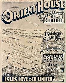
The area was designated as an agricultural reserve in the 1860s, and residential development began in the 1880s.[6] The population grew significantly after 1935 when the Hornibrook Bridge was opened; the two lane, 2.8 kilometres (1.7 mi) bridge crossed Bramble Bay and linked the peninsula with a more direct route to Brisbane. A replacement three lane bridge, the Houghton Highway, opened in 1979. On 11 July 2010 the new three lane Ted Smout Memorial Bridge opened, and at 2.7 kilometres (1.7 mi) is claimed to be Australia's longest. The bridge was named to honour Queensland's longest surviving World War 1 Digger. It provides south-bound traffic flow as well as pedestrian and bicycle access, while the Houghton Highway has become a dedicated north-bound traffic bridge.
The Redcliffe Library opened in 2000.[7]
In 2007 the Queensland Government's Local Government Reform Commission announced that Redcliffe would be amalgamated into the adjoining Pine Rivers and Caboolture shires to form the Moreton Bay Region.
Population
Redcliffe's population is 51,174[8] with a female skew. The 2006 census showed that Redcliffe's population of indigenous origins was 1.9% (2.0% 2001 Census), 27.2% (19.9%) were born overseas, and 5.1% (4.7%) of the population speaks a language other than English at home.
| Male | Female | Total | |
|---|---|---|---|
| Total persons excluding overseas visitors |
24,535 | 26,639 | 51,174 |
| Aged 15 years and over | 19,795 | 22,275 | 42,070 |
| Aged 65 years and over | 4,109 | 5,694 | 9,803 |
| Indigenous | 510 | 507 | 1,017 |
| Aged 18 years and over | 270 | 309 | 579 |
| Born in Australia | 18,032 | 19,612 | 37,644 |
| Born overseas Includes 'Inadequately described', 'At sea', and 'Not elsewhere classified' |
4,912 | 5,340 | 10,252 |
| Source: Australian Bureau of Statistics[8] | |||
Economy
The major economical sectors of Redcliffe are retail trade, construction trades, medical and community services, and property and business services, followed by automotive, manufacturing, and cafés, hotels, restaurants and takeaways.[9] Fishing and prawning are the principal primary industries, with mostly light industries located at Clontarf and Kippa-Ring.
Tourism is an important industry to the area with approximately 1.2 million tourists visiting each year.[10] This focus on tourism has existed since the late 1800s when people came by boat to enjoy its safe, sheltered and sandy beaches.
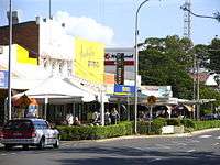
The major shopping areas are the Redcliffe Seaside Village (Redcliffe Parade & Sutton Street) which incorporates numerous boutique shops, restaurants, cafe's, a 7D Cinema,[11] and the Bluewater Square Shopping Centre housing a Woolworths. The Peninsula Fair and Kippa-Ring Shopping Centres are built side by side in Kippa-Ring in the centre of the Peninsula and boast the area's dominant retail centre with over 120 specialty stores between them, including K-Mart, Target, Woolworths, Coles, Best & Less and Hoyt's Cinemas.
Smaller shopping centres are at Margate, Scarborough, Woody Point, Clontarf and Rothwell. The Newport development has proposed a new retail and town centre for the suburb which is currently lacking its own local services.
Climate
Redcliffe has a humid subtropical climate under the Köppen climate classification system, with hot, humid summers and dry, mild winters. Thunderstorms are regular events from late Spring to early Autumn in the late afternoon to early evening. The more severe storms are accompanied by damaging hail stones, torrential rain and destructive winds, however as most storms travel in a north-east direction from past Ipswich then over greater Brisbane, they often lose strength by the time they arrive to Redcliffe.
| Climate data for Redcliffe | |||||||||||||
|---|---|---|---|---|---|---|---|---|---|---|---|---|---|
| Month | Jan | Feb | Mar | Apr | May | Jun | Jul | Aug | Sep | Oct | Nov | Dec | Year |
| Average high °C (°F) | 29.0 (84.2) |
28.5 (83.3) |
27.7 (81.9) |
25.6 (78.1) |
23.3 (73.9) |
21.2 (70.2) |
20.6 (69.1) |
21.4 (70.5) |
24.1 (75.4) |
25.3 (77.5) |
26.6 (79.9) |
28.0 (82.4) |
25.1 (77.2) |
| Average low °C (°F) | 21.9 (71.4) |
21.6 (70.9) |
20.2 (68.4) |
17.7 (63.9) |
14.9 (58.8) |
11.6 (52.9) |
10.6 (51.1) |
11.1 (52) |
14.1 (57.4) |
16.5 (61.7) |
18.7 (65.7) |
20.7 (69.3) |
16.6 (61.9) |
| Average precipitation mm (inches) | 111.6 (4.394) |
160.9 (6.335) |
126.8 (4.992) |
124.4 (4.898) |
89.0 (3.504) |
59.9 (2.358) |
51.3 (2.02) |
39.7 (1.563) |
30.2 (1.189) |
70.5 (2.776) |
101.6 (4) |
117.8 (4.638) |
1,064.1 (41.894) |
| Source: Bureau of Meteorology[12] | |||||||||||||
Landmarks
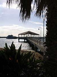
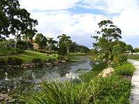
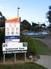
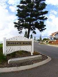
There are a number of landmarks located in Redcliffe, such as the Redcliffe Jetty, Settlement Cove Lagoon, Suttons and Margate Beaches, Scarborough Beach Park with its Cottonwood trees, Redcliffe Museum, Woody Point Jetty, HMQS Gayundah shipwreck, and two bridges that have become iconic to Redcliffe, the Houghton Highway and Ted Smout Memorial Bridge,which links Redcliffe to the Brisbane suburb of Brighton. Redcliffe features many buildings by the heritage designer-builder Alex Smith. On 14 February 2013 the Bee Gees Way in the Redcliffe CBD was opened and features a statue of the Bee Gees in their youth as residents of Redcliffe. The Bee Gees Way was formerly a pathway that was gazetted for weekend markets.
The Moreton Bay Regional Council operates a public library at 476 Oxley Avenue, Redcliffe.[13]
Moreton Bay
Redcliffe City acts as a service centre for the Moreton Bay island communities, a tourist hub for the bay, and base of operations for local fishing and the seafood industry. From Redcliffe visitors can access Moreton Island via a new passenger ferry that has replaced the old Combie Trader ferry, Deception Bay waters, Bramble Bay, Hays Inlet and the Pine River leading to the North and South Pine rivers. The major marina in Redcliffe is Scarborough Marina, located in the Scarborough Boat Harbour, at the northern tip of the Peninsula; Newport Waterways Marina is nearby.
Sport, recreation and events
A seaside location with 22 kilometres (14 mi) of coastline and a mainly working class population, Redcliffe has a high emphasis on sport and recreation. More than 35 kilometres (22 mi) of dedicated bikeways surround the peninsula, and local sporting clubs include baseball, croquet, golf, hockey, lawn bowls, netball, softball, tennis, rugby, football, Australian football and touch football. Scouting and Guiding groups are also in Redcliffe.
Most weekends free-fall tandem skydivers can be seen dropping from 14,000 feet (4,300 m), landing onto Suttons Beach. The operator uses a Cessna 208 Caravan, holding up to ten people, that departs from local Redcliffe Airport.
Redcliffe Dimensions 7D Cinema,[14]<[15] which opened its doors late 2016, is a family entertainment venue that offers a virtual ride experience suitable from ages 2+. RD7D also have a mobile 7D Cinema available for hire throughout the region, for private and public events, and have already been involved with many events organised by MBRIT[16] such as the Sails Festival and Kitefest.
Kite flying with the Queensland Kite Flyers Society is held twice a month at Pelican Park on Hornibrook Esplanade, Clontarf. Each May, the council hosts a large kite-flying event called Kitefest.
The Redcliffe Dolphins are a rugby league team that competes in the Queensland Cup. The team's grounds is Dolphin Oval in Kippa-Ring.
Peninsula Power Football Club is a football (soccer) club in Redcliffe. Formed in 2000 from a merger between Margate and Redcliffe Soccer Clubs, the team competes in the Brisbane Premier League.
The Redcliffe Padres are located at Talobilla Park in Kippa Ring.
Scuba divers can be seen diving from local shore sites Queens Reef in Scarborough, and the Redcliffe jetty in the town centre, as well as several boats which depart for diving in the wider Moreton Bay area.
To celebrate the start of the Brisbane to Gladstone yacht race, the Festival of Sails event is held yearly on Good Friday.
In September, Redcliffe celebrates its history and status as Queensland's first European settlement location with an annual First Settlement Festival.
Transport
Bus public transport is provided by local company Hornibrook Bus Lines. Services include local routes within the city area, to the Brisbane central business district via Pine Rivers Shire and Petrie railway station, to Sandgate railway station via Brighton with connecting QR Citytrain services to Brisbane, and a weekday direct Cityxpress service with limited stopping. Kangaroo Bus Lines provides a connection from Redcliffe to Caboolture via Deception Bay and Morayfield.
Road taxi services are provided by Redcliffe Taxi Service.
A heavy rail Citytrain passenger service to Kippa-Ring opened in October 2016.
The Redcliffe Airport is an aerodrome straddling the Kippa-Ring and Rothwell suburb boundaries, just south of the Deception Bay inlet from Moreton Bay. With an 853 m runway (07/25), it is owned and operated by the Redcliffe City Council. The Redcliffe Aero Club is based at the airport and provides pilot training, aircraft hire and charter services.
Local media
Redcliffe has a weekly local newspaper, the Redcliffe and Bayside Herald, a Quest Community Newspapers masthead owned by News Corporation. Another local news source is community website redcliffecity.com.au, developed by local woman Lynda Roberts of The Redcliffe City News Pty Ltd, supplemented with a limited distribution of a paper publication via local businesses.
Community radio station 99 Seven is based in Redcliffe and covers the city and surrounding Pine Rivers and northern Brisbane suburbs. The station, founded in 1986, broadcasts on the 99.7 MHz FM frequency (4RED) and offers a broad range of genres in programming and music.
Notable people from Redcliffe
Member of the Queensland Parliament and prominent former United Retail Federation National President Scott Driscoll proudly promotes that he is "Redcliffe Born and Bred". Mr Driscoll is also known for resigning from state politics 48 hours before being kicked out.[17]
Barry, Robin and Maurice Gibb of the Bee Gees moved to Redcliffe in the late 1950s and formed the Bee Gees.
Actors William McInnes and Nikki Osborne come from Redcliffe. The film Swimming Upstream starring Geoffrey Rush used the Redcliffe War Memorial Pool as one of its locations.
Redcliffe has a high number of Olympic Games athletes from its relatively small population, including swimmers Leisel Jones, Geoff Huegill, Jessicah Schipper and Tarnee White who trained in Scarborough under coach Ken Wood.
Current Kookaburras Head Coach (Australian Men's Hockey Team)[18] - Graham Reid played all his junior hockey with Redcliffe during the 1970s attended both Scarborough and Clontarf state schools and began his coaching career coaching Redcliffe to a premiership in 1989.
Rugby league players Travis Norton, Petero Civoniceva, Brent Tate, Michael Crocker, Adam Mogg and Arthur Beetson were either born in Redcliffe or started their sporting careers from playing here.
Author Kim Wilkins grew up in Redcliffe.
Sister cities
The City of Redcliffe, through the Redcliffe City Council, has two Sister City arrangements:[19]
References
- ↑ http://stat.abs.gov.au/itt/r.jsp?RegionSummary®ion=31305&dataset=ABS_REGIONAL_ASGS&geoconcept=REGION&datasetASGS=ABS_REGIONAL_ASGS&datasetLGA=ABS_NRP9_LGA®ionLGA=REGION®ionASGS=REGION
- 1 2 3 Potter, Ron. "Place Names of South East Queensland". Piula Publications. Archived from the original on 23 May 2008. Retrieved 17 May 2008.
- 1 2 3 "Redcliffe". Travel. The Sydney Morning Herald. 8 February 2004. Retrieved 2008-05-17.
- 1 2 "Exhibitions at Redcliffe Museum". Redcliffe City Council. 2005. Archived from the original on 19 July 2008. Retrieved 17 May 2008.
- ↑ Petrie, Constance Campbell; Petrie, Tom, 1831–1910 (1992), Tom Petrie's reminiscences of early Queensland (4th ed.), University of Queensland Press, p. 317, ISBN 978-0-7022-2383-9
- ↑ The Brisbane Courier Saturday 15 January 1881 - Humpybong-Redcliffe
- ↑ "Queensland Public Libraries Statistical Bulletin 2016-2017" (PDF). Public Libraries Connect. State Library of Queensland. November 2017. p. 14. Retrieved 26 January 2018.
- 1 2 Australian Bureau of Statistics (25 October 2007). "Redcliffe (C) (Local Government Area)". 2006 Census QuickStats. Retrieved 2007-08-03.
- ↑ "About Redcliffe". Redcliffe City Council. 3 February 2006. Archived from the original on 17 November 2007. Retrieved 4 January 2007.
- ↑ "Welcome to Redcliffe". Redcliffe Tourism. Redcliffe City Council. 2006-12-05. Retrieved 2007-01-04.
- ↑ Quinney, Alan (31 August 2016). "Small Business: 7D cinema opens at Redcliffe". Quest Community Newspapers. Retrieved 29 January 2017.
- ↑ "Redcliffe City AWS". Climate statistics for Australian locations. Bureau of Meteorology. Retrieved 2007-08-03.
- ↑ "Redcliffe Library". Public Libraries Connect. State Library of Queensland. 5 October 2017. Retrieved 26 January 2018.
- ↑ "Redcliffe Dimensions — 7D Experience". www.rd7d.com.au. Retrieved 2017-01-28.
- ↑ "Virtual Reality And Interactive Cinema In Redcliffe • Brisbane Kids". Brisbane Kids. 2016-09-21. Retrieved 2017-01-28.
- ↑ "About Us - Visit Moreton Bay Region". Visit Moreton Bay Region. Retrieved 2017-01-28.
- ↑ The Courier Mail Wednesday 20 November 2013 Pg 1
- ↑ http://www.hillsecho.com/redcliffe-hockey-celebrates-80-years/
- ↑ "Council A-Z Services". Redcliffe City Council. 2006. Retrieved 2007-01-04.